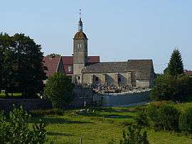
Dompierre-sur-Mont
| Dompierre-sur-Mont | |
|---|---|
 | |
 Dompierre-sur-Mont | |
|
Location within Bourgogne-Franche-Comté region  Dompierre-sur-Mont | |
| Coordinates: 46°33′35″N 5°36′34″E / 46.5597°N 5.6094°ECoordinates: 46°33′35″N 5°36′34″E / 46.5597°N 5.6094°E | |
| Country | France |
| Region | Bourgogne-Franche-Comté |
| Department | Jura |
| Arrondissement | Lons-le-Saunier |
| Canton | Orgelet |
| Government | |
| • Mayor (2014–2020) | Guy Piétriga |
| Area1 | 7.37 km2 (2.85 sq mi) |
| Population (2012)2 | 244 |
| • Density | 33/km2 (86/sq mi) |
| Time zone | CET (UTC+1) |
| • Summer (DST) | CEST (UTC+2) |
| INSEE/Postal code | 39200 / 39270 |
| Elevation | 486–644 m (1,594–2,113 ft) |
|
1 French Land Register data, which excludes lakes, ponds, glaciers > 1 km² (0.386 sq mi or 247 acres) and river estuaries. 2 Population without double counting: residents of multiple communes (e.g., students and military personnel) only counted once. | |
Dompierre-sur-Mont is a commune in the Jura department in Franche-Comté in eastern France.
Population
| Historical population | ||
|---|---|---|
| Year | Pop. | ±% |
| 1793 | 317 | — |
| 1806 | 341 | +7.6% |
| 1821 | 340 | −0.3% |
| 1831 | 394 | +15.9% |
| 1841 | 350 | −11.2% |
| 1851 | 352 | +0.6% |
| 1861 | 334 | −5.1% |
| 1872 | 320 | −4.2% |
| 1881 | 291 | −9.1% |
| 1891 | 263 | −9.6% |
| 1901 | 235 | −10.6% |
| 1911 | 221 | −6.0% |
| 1921 | 216 | −2.3% |
| 1931 | 208 | −3.7% |
| 1946 | 187 | −10.1% |
| 1954 | 168 | −10.2% |
| 1962 | 143 | −14.9% |
| 1968 | 116 | −18.9% |
| 1975 | 138 | +19.0% |
| 1982 | 193 | +39.9% |
| 1990 | 171 | −11.4% |
| 1999 | 179 | +4.7% |
| 2006 | 222 | +24.0% |
| 2012 | 244 | +9.9% |
See also
References
| Wikimedia Commons has media related to Dompierre-sur-Mont. |
This article is issued from Wikipedia - version of the 3/15/2016. The text is available under the Creative Commons Attribution/Share Alike but additional terms may apply for the media files.