Septfontaines, Doubs
| Septfontaines | |
|---|---|
 | |
 Septfontaines | |
|
Location within Bourgogne-Franche-Comté region  Septfontaines | |
| Coordinates: 46°58′58″N 6°11′02″E / 46.9828°N 6.1839°ECoordinates: 46°58′58″N 6°11′02″E / 46.9828°N 6.1839°E | |
| Country | France |
| Region | Bourgogne-Franche-Comté |
| Department | Doubs |
| Arrondissement | Pontarlier |
| Canton | Levier |
| Intercommunality | Altitude 800 |
| Government | |
| • Mayor (2008–2014) | Christian Ratte |
| Area1 | 18.37 km2 (7.09 sq mi) |
| Population (2012)2 | 331 |
| • Density | 18/km2 (47/sq mi) |
| Time zone | CET (UTC+1) |
| • Summer (DST) | CEST (UTC+2) |
| INSEE/Postal code | 25541 / 25270 |
| Elevation | 700–810 m (2,300–2,660 ft) |
|
1 French Land Register data, which excludes lakes, ponds, glaciers > 1 km² (0.386 sq mi or 247 acres) and river estuaries. 2 Population without double counting: residents of multiple communes (e.g., students and military personnel) only counted once. | |
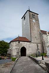
Septfontaines is a commune in the Doubs department in the Bourgogne-Franche-Comté region in eastern France.
Geography
Septfontaines lies on the ancient royal road between Besançon and Pontarlier 6 km (3.7 mi) northeast of Pontarlier near the Swiss border.
Population
| Historical population | ||
|---|---|---|
| Year | Pop. | ±% |
| 1962 | 255 | — |
| 1968 | 276 | +8.2% |
| 1975 | 254 | −8.0% |
| 1982 | 236 | −7.1% |
| 1990 | 233 | −1.3% |
| 1999 | 254 | +9.0% |
| 2008 | 320 | +26.0% |
| 2012 | 331 | +3.4% |
See also
References
External links
| Wikimedia Commons has media related to Septfontaines (France). |
This article is issued from Wikipedia - version of the 10/29/2016. The text is available under the Creative Commons Attribution/Share Alike but additional terms may apply for the media files.