Montperreux
| Montperreux | |
|---|---|
 | |
 Montperreux | |
|
Location within Bourgogne-Franche-Comté region  Montperreux | |
| Coordinates: 46°49′36″N 6°20′32″E / 46.8267°N 6.3422°ECoordinates: 46°49′36″N 6°20′32″E / 46.8267°N 6.3422°E | |
| Country | France |
| Region | Bourgogne-Franche-Comté |
| Department | Doubs |
| Arrondissement | Pontarlier |
| Canton | Pontarlier |
| Intercommunality | Mont d'Or et des Deux Lacs |
| Government | |
| • Mayor (2008–2014) | Jean-Paul Bonnet |
| Area1 | 11.61 km2 (4.48 sq mi) |
| Population (2012)2 | 770 |
| • Density | 66/km2 (170/sq mi) |
| Time zone | CET (UTC+1) |
| • Summer (DST) | CEST (UTC+2) |
| INSEE/Postal code | 25405 / 25160 |
| Elevation | 848–1,112 m (2,782–3,648 ft) |
|
1 French Land Register data, which excludes lakes, ponds, glaciers > 1 km² (0.386 sq mi or 247 acres) and river estuaries. 2 Population without double counting: residents of multiple communes (e.g., students and military personnel) only counted once. | |
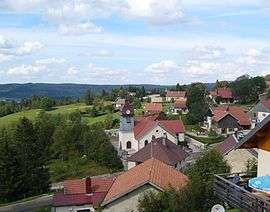
Montperreux is a commune in the Doubs department in the Bourgogne-Franche-Comté region in eastern France.
Geography
Montperreux lies 11 km (6.8 mi) south of Pontarlier in the Jura mountains.
Population
| Historical population | ||
|---|---|---|
| Year | Pop. | ±% |
| 1962 | 192 | — |
| 1968 | 201 | +4.7% |
| 1975 | 215 | +7.0% |
| 1982 | 251 | +16.7% |
| 1990 | 422 | +68.1% |
| 1999 | 605 | +43.4% |
| 2008 | 768 | +26.9% |
| 2012 | 770 | +0.3% |
See also
References
External links
| Wikimedia Commons has media related to Montperreux. |
This article is issued from Wikipedia - version of the 10/29/2016. The text is available under the Creative Commons Attribution/Share Alike but additional terms may apply for the media files.