Téthieu
| Téthieu | |
|---|---|
|
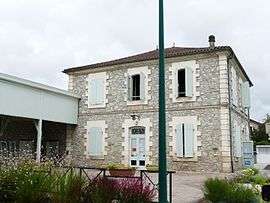
Town hall | |
 Téthieu | |
|
Location within Nouvelle-Aquitaine region  Téthieu | |
| Coordinates: 43°45′08″N 0°58′25″W / 43.7522°N 0.9736°WCoordinates: 43°45′08″N 0°58′25″W / 43.7522°N 0.9736°W | |
| Country | France |
| Region | Nouvelle-Aquitaine |
| Department | Landes |
| Arrondissement | Dax |
| Canton | Dax-Nord |
| Intercommunality | Grand Dax |
| Government | |
| • Mayor (2014–2020) | Jean-Michel Dufort |
| Area1 | 11.03 km2 (4.26 sq mi) |
| Population (2013)2 | 695 |
| • Density | 63/km2 (160/sq mi) |
| Time zone | CET (UTC+1) |
| • Summer (DST) | CEST (UTC+2) |
| INSEE/Postal code | 40315 / 40990 |
| Elevation |
4–34 m (13–112 ft) (avg. 10 m or 33 ft) |
|
1 French Land Register data, which excludes lakes, ponds, glaciers > 1 km² (0.386 sq mi or 247 acres) and river estuaries. 2 Population without double counting: residents of multiple communes (e.g., students and military personnel) only counted once. | |
Téthieu is a commune in the Landes department in Nouvelle-Aquitaine in southwestern France.
Population
| Historical population | ||
|---|---|---|
| Year | Pop. | ±% |
| 1793 | 266 | — |
| 1806 | 313 | +17.7% |
| 1821 | 318 | +1.6% |
| 1831 | 390 | +22.6% |
| 1841 | 392 | +0.5% |
| 1851 | 443 | +13.0% |
| 1861 | 581 | +31.2% |
| 1872 | 586 | +0.9% |
| 1881 | 636 | +8.5% |
| 1891 | 601 | −5.5% |
| 1901 | 582 | −3.2% |
| 1911 | 539 | −7.4% |
| 1921 | 524 | −2.8% |
| 1931 | 487 | −7.1% |
| 1946 | 467 | −4.1% |
| 1954 | 455 | −2.6% |
| 1962 | 486 | +6.8% |
| 1968 | 488 | +0.4% |
| 1975 | 466 | −4.5% |
| 1982 | 486 | +4.3% |
| 1990 | 485 | −0.2% |
| 1999 | 494 | +1.9% |
| 2008 | 633 | +28.1% |
| 2013 | 695 | +9.8% |
See also
References
| Wikimedia Commons has media related to Téthieu. |
This article is issued from Wikipedia - version of the 11/10/2016. The text is available under the Creative Commons Attribution/Share Alike but additional terms may apply for the media files.