Leers
| Leers | ||
|---|---|---|
 | ||
| ||
 Leers | ||
|
Location within Hauts-de-France region  Leers | ||
| Coordinates: 50°40′57″N 3°14′41″E / 50.6825°N 3.2447°ECoordinates: 50°40′57″N 3°14′41″E / 50.6825°N 3.2447°E | ||
| Country | France | |
| Region | Hauts-de-France | |
| Department | Nord | |
| Arrondissement | Lille | |
| Canton | Lannoy | |
| Intercommunality | Lille Métropole | |
| Government | ||
| • Mayor (2008–2014) | Jean-Claude Van Belle | |
| Area1 | 5.4 km2 (2.1 sq mi) | |
| Population (1999)2 | 9,651 | |
| • Density | 1,800/km2 (4,600/sq mi) | |
| Time zone | CET (UTC+1) | |
| • Summer (DST) | CEST (UTC+2) | |
| INSEE/Postal code | 59339 / 59115 | |
| Elevation |
16–37 m (52–121 ft) (avg. 37 m or 121 ft) | |
|
1 French Land Register data, which excludes lakes, ponds, glaciers > 1 km² (0.386 sq mi or 247 acres) and river estuaries. 2 Population without double counting: residents of multiple communes (e.g., students and military personnel) only counted once. | ||
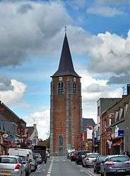
Leers is a commune in the Nord department in northern France.
It is part of the Urban Community of Lille Métropole, and is about 15 km (9.3 mi) northeast of Lille.
Heraldry
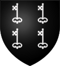 |
The arms of Leers are blazoned : Sable, 4 keys argent. (Leers and Saint-Pierre-Brouck use the same arms.) |
See also
References
| Wikimedia Commons has media related to Leers (Nord). |
.svg.png)
This article is issued from Wikipedia - version of the 11/22/2016. The text is available under the Creative Commons Attribution/Share Alike but additional terms may apply for the media files.