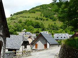
Mayrègne
| Mayrègne | |
|---|---|
 | |
 Mayrègne | |
|
Location within Occitanie region  Mayrègne | |
| Coordinates: 42°50′41″N 0°32′25″E / 42.8447°N 0.5403°ECoordinates: 42°50′41″N 0°32′25″E / 42.8447°N 0.5403°E | |
| Country | France |
| Region | Occitanie |
| Department | Haute-Garonne |
| Arrondissement | Saint-Gaudens |
| Canton | Bagnères-de-Luchon |
| Government | |
| • Mayor (2008–2014) | Louis Fernandez |
| Area1 | 5.19 km2 (2.00 sq mi) |
| Population (2011)2 | 29 |
| • Density | 5.6/km2 (14/sq mi) |
| Time zone | CET (UTC+1) |
| • Summer (DST) | CEST (UTC+2) |
| INSEE/Postal code | 31335 / 31110 |
| Elevation |
1,120–1,914 m (3,675–6,280 ft) (avg. 1,180 m or 3,870 ft) |
|
1 French Land Register data, which excludes lakes, ponds, glaciers > 1 km² (0.386 sq mi or 247 acres) and river estuaries. 2 Population without double counting: residents of multiple communes (e.g., students and military personnel) only counted once. | |
Mayrègne is a commune in the Haute-Garonne department in southwestern France.
Population
| Historical population | ||
|---|---|---|
| Year | Pop. | ±% |
| 1962 | 67 | — |
| 1968 | 36 | −46.3% |
| 1975 | 35 | −2.8% |
| 1982 | 23 | −34.3% |
| 1990 | 21 | −8.7% |
| 1999 | 33 | +57.1% |
| 2008 | 24 | −27.3% |
| 2011 | 29 | +20.8% |
See also
References
| Wikimedia Commons has media related to Mayrègne. |
This article is issued from Wikipedia - version of the 7/20/2016. The text is available under the Creative Commons Attribution/Share Alike but additional terms may apply for the media files.