Saint-Julia
| Saint-Julia | ||
|---|---|---|
.jpg) | ||
| ||
 Saint-Julia | ||
|
Location within Occitanie region  Saint-Julia | ||
| Coordinates: 43°29′28″N 1°53′54″E / 43.4911°N 1.8983°ECoordinates: 43°29′28″N 1°53′54″E / 43.4911°N 1.8983°E | ||
| Country | France | |
| Region | Occitanie | |
| Department | Haute-Garonne | |
| Arrondissement | Toulouse | |
| Canton | Revel | |
| Intercommunality | Lauragais-Revel-Sorezois | |
| Government | ||
| • Mayor (2008–2014) | Raymond Martinazzo | |
| Area1 | 11.46 km2 (4.42 sq mi) | |
| Population (2008)2 | 376 | |
| • Density | 33/km2 (85/sq mi) | |
| Time zone | CET (UTC+1) | |
| • Summer (DST) | CEST (UTC+2) | |
| INSEE/Postal code | 31491 / 31540 | |
| Elevation |
200–301 m (656–988 ft) (avg. 293 m or 961 ft) | |
|
1 French Land Register data, which excludes lakes, ponds, glaciers > 1 km² (0.386 sq mi or 247 acres) and river estuaries. 2 Population without double counting: residents of multiple communes (e.g., students and military personnel) only counted once. | ||
.svg.png)
Saint-Julia is a commune in the Haute-Garonne department in southwestern France.
Population
| Historical population | ||
|---|---|---|
| Year | Pop. | ±% |
| 1962 | 300 | — |
| 1968 | 382 | +27.3% |
| 1975 | 370 | −3.1% |
| 1982 | 314 | −15.1% |
| 1990 | 305 | −2.9% |
| 1999 | 333 | +9.2% |
| 2008 | 376 | +12.9% |
.jpg) Church and Town hall
Church and Town hall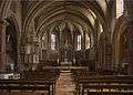 Interior of church
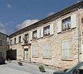 Town hall
See also
References
| Wikimedia Commons has media related to Saint-Julia. |
This article is issued from Wikipedia - version of the 10/23/2016. The text is available under the Creative Commons Attribution/Share Alike but additional terms may apply for the media files.