Labastide-Saint-Sernin
| Labastide-Saint-Sernin | ||
|---|---|---|
 | ||
| ||
 Labastide-Saint-Sernin | ||
|
Location within Occitanie region  Labastide-Saint-Sernin | ||
| Coordinates: 43°44′23″N 1°28′19″E / 43.7397°N 1.4719°ECoordinates: 43°44′23″N 1°28′19″E / 43.7397°N 1.4719°E | ||
| Country | France | |
| Region | Occitanie | |
| Department | Haute-Garonne | |
| Arrondissement | Toulouse | |
| Canton | Fronton | |
| Government | ||
| • Mayor (2008–2014) | Bertrand Sarrau | |
| Area1 | 4.97 km2 (1.92 sq mi) | |
| Population (2008)2 | 1,756 | |
| • Density | 350/km2 (920/sq mi) | |
| Time zone | CET (UTC+1) | |
| • Summer (DST) | CEST (UTC+2) | |
| INSEE/Postal code | 31252 / 31620 | |
| Elevation |
126–184 m (413–604 ft) (avg. 130 m or 430 ft) | |
|
1 French Land Register data, which excludes lakes, ponds, glaciers > 1 km² (0.386 sq mi or 247 acres) and river estuaries. 2 Population without double counting: residents of multiple communes (e.g., students and military personnel) only counted once. | ||
.svg.png)
Labastide-Saint-Sernin is a commune in the Haute-Garonne department in southwestern France.
Population
| Historical population | ||
|---|---|---|
| Year | Pop. | ±% |
| 1962 | 181 | — |
| 1968 | 380 | +109.9% |
| 1975 | 603 | +58.7% |
| 1982 | 980 | +62.5% |
| 1990 | 1,208 | +23.3% |
| 1999 | 1,329 | +10.0% |
| 2008 | 1,756 | +32.1% |
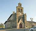
Sights
- Church
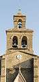 Bell gables
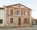 Town Hall
See also
Communes of the Haute-Garonne department
References
| Wikimedia Commons has media related to Labastide-Saint-Sernin. |
This article is issued from Wikipedia - version of the 12/28/2014. The text is available under the Creative Commons Attribution/Share Alike but additional terms may apply for the media files.