Bezins-Garraux
| Bezins-Garraux | |
|---|---|
|
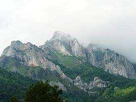
Pic du Gar | |
 Bezins-Garraux | |
|
Location within Occitanie region  Bezins-Garraux | |
| Coordinates: 42°55′56″N 0°41′30″E / 42.9322°N 0.6917°ECoordinates: 42°55′56″N 0°41′30″E / 42.9322°N 0.6917°E | |
| Country | France |
| Region | Occitanie |
| Department | Haute-Garonne |
| Arrondissement | Saint-Gaudens |
| Canton | Saint-Béat |
| Intercommunality | Canton de Saint-Béat |
| Government | |
| • Mayor (2008–2014) | Ernest Dat |
| Area1 | 7.71 km2 (2.98 sq mi) |
| Population (2008)2 | 55 |
| • Density | 7.1/km2 (18/sq mi) |
| Time zone | CET (UTC+1) |
| • Summer (DST) | CEST (UTC+2) |
| INSEE/Postal code | 31067 / 31440 |
| Elevation |
568–1,788 m (1,864–5,866 ft) (avg. 711 m or 2,333 ft) |
|
1 French Land Register data, which excludes lakes, ponds, glaciers > 1 km² (0.386 sq mi or 247 acres) and river estuaries. 2 Population without double counting: residents of multiple communes (e.g., students and military personnel) only counted once. | |
Bezins-Garraux is a commune in the Haute-Garonne department in southwestern France.
Population
| Historical population | ||
|---|---|---|
| Year | Pop. | ±% |
| 1962 | 21 | — |
| 1968 | 47 | +123.8% |
| 1975 | 44 | −6.4% |
| 1982 | 38 | −13.6% |
| 1990 | 46 | +21.1% |
| 1999 | 39 | −15.2% |
| 2008 | 55 | +41.0% |
See also
References
| Wikimedia Commons has media related to Bezins-Garraux. |
This article is issued from Wikipedia - version of the 9/17/2015. The text is available under the Creative Commons Attribution/Share Alike but additional terms may apply for the media files.