Jurvielle
| Jurvielle | |
|---|---|
 | |
 Jurvielle | |
|
Location within Occitanie region  Jurvielle | |
| Coordinates: 42°49′06″N 0°29′14″E / 42.8183°N 0.4872°ECoordinates: 42°49′06″N 0°29′14″E / 42.8183°N 0.4872°E | |
| Country | France |
| Region | Occitanie |
| Department | Haute-Garonne |
| Arrondissement | Saint-Gaudens |
| Canton | Bagnères-de-Luchon |
| Government | |
| • Mayor (2008–2014) | Stéphan Tine |
| Area1 | 5.79 km2 (2.24 sq mi) |
| Population (2008)2 | 20 |
| • Density | 3.5/km2 (8.9/sq mi) |
| Time zone | CET (UTC+1) |
| • Summer (DST) | CEST (UTC+2) |
| INSEE/Postal code | 31242 / 31110 |
| Elevation |
1,240–2,093 m (4,068–6,867 ft) (avg. 1,250 m or 4,100 ft) |
|
1 French Land Register data, which excludes lakes, ponds, glaciers > 1 km² (0.386 sq mi or 247 acres) and river estuaries. 2 Population without double counting: residents of multiple communes (e.g., students and military personnel) only counted once. | |
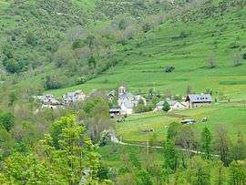
Jurvielle is a commune in the Haute-Garonne department in southwestern France.
Population
| Historical population | ||
|---|---|---|
| Year | Pop. | ±% |
| 1962 | 40 | — |
| 1968 | 49 | +22.5% |
| 1975 | 31 | −36.7% |
| 1982 | 19 | −38.7% |
| 1990 | 18 | −5.3% |
| 1999 | 17 | −5.6% |
| 2008 | 20 | +17.6% |
See also
Communes of the Haute-Garonne department
References
| Wikimedia Commons has media related to Jurvielle. |
This article is issued from Wikipedia - version of the 3/21/2014. The text is available under the Creative Commons Attribution/Share Alike but additional terms may apply for the media files.