Cros, Gard
| Cros | ||
|---|---|---|
|
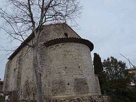
The church of Cros | ||
| ||
 Cros | ||
|
Location within Occitanie region  Cros | ||
| Coordinates: 43°59′38″N 3°49′33″E / 43.994°N 3.8258°ECoordinates: 43°59′38″N 3°49′33″E / 43.994°N 3.8258°E | ||
| Country | France | |
| Region | Occitanie | |
| Department | Gard | |
| Arrondissement | Le Vigan | |
| Canton | Saint-Hippolyte-du-Fort | |
| Intercommunality | Cévennes-Garrigues | |
| Government | ||
| • Mayor (2008–2014) | André Alègre | |
| Area1 | 16.94 km2 (6.54 sq mi) | |
| Population (2008)2 | 252 | |
| • Density | 15/km2 (39/sq mi) | |
| Time zone | CET (UTC+1) | |
| • Summer (DST) | CEST (UTC+2) | |
| INSEE/Postal code | 30099 / 30170 | |
| Elevation |
178–964 m (584–3,163 ft) (avg. 235 m or 771 ft) | |
|
1 French Land Register data, which excludes lakes, ponds, glaciers > 1 km² (0.386 sq mi or 247 acres) and river estuaries. 2 Population without double counting: residents of multiple communes (e.g., students and military personnel) only counted once. | ||
.svg.png)
Cros (pronounced cross, not crow) is a commune in the Gard department in southern France.
Population
| Historical population | ||
|---|---|---|
| Year | Pop. | ±% |
| 1962 | 208 | — |
| 1968 | 249 | +19.7% |
| 1975 | 229 | −8.0% |
| 1982 | 230 | +0.4% |
| 1990 | 234 | +1.7% |
| 1999 | 213 | −9.0% |
| 2008 | 252 | +18.3% |
See also
References
| Wikimedia Commons has media related to Cros (Gard). |
This article is issued from Wikipedia - version of the 11/7/2016. The text is available under the Creative Commons Attribution/Share Alike but additional terms may apply for the media files.