Aujac, Gard
| Aujac | ||
|---|---|---|
|
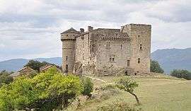
The Chateau du Cheylard in Aujac | ||
| ||
 Aujac | ||
|
Location within Occitanie region  Aujac | ||
| Coordinates: 44°21′00″N 4°00′54″E / 44.35°N 4.015°ECoordinates: 44°21′00″N 4°00′54″E / 44.35°N 4.015°E | ||
| Country | France | |
| Region | Occitanie | |
| Department | Gard | |
| Arrondissement | Alès | |
| Canton | Génolhac | |
| Intercommunality | Hautes Cévennes | |
| Government | ||
| • Mayor (2001–2008) | André Agniel | |
| Area1 | 16.47 km2 (6.36 sq mi) | |
| Population (2008)2 | 183 | |
| • Density | 11/km2 (29/sq mi) | |
| Time zone | CET (UTC+1) | |
| • Summer (DST) | CEST (UTC+2) | |
| INSEE/Postal code | 30022 / 30450 | |
| Elevation |
256–940 m (840–3,084 ft) (avg. 500 m or 1,600 ft) | |
|
1 French Land Register data, which excludes lakes, ponds, glaciers > 1 km² (0.386 sq mi or 247 acres) and river estuaries. 2 Population without double counting: residents of multiple communes (e.g., students and military personnel) only counted once. | ||
.svg.png)
Aujac is a commune in the Gard department in southern France.
Population
| Historical population | ||
|---|---|---|
| Year | Pop. | ±% |
| 1793 | 492 | — |
| 1821 | 686 | +39.4% |
| 1846 | 921 | +34.3% |
| 1872 | 753 | −18.2% |
| 1901 | 620 | −17.7% |
| 1921 | 524 | −15.5% |
| 1946 | 295 | −43.7% |
| 1962 | 128 | −56.6% |
| 1968 | 158 | +23.4% |
| 1975 | 135 | −14.6% |
| 1982 | 148 | +9.6% |
| 1990 | 154 | +4.1% |
| 1999 | 166 | +7.8% |
| 2008 | 183 | +10.2% |
See also
References
| Wikimedia Commons has media related to Aujac (Gard). |
This article is issued from Wikipedia - version of the 11/6/2016. The text is available under the Creative Commons Attribution/Share Alike but additional terms may apply for the media files.