Arphy
| Arphy | ||
|---|---|---|
|
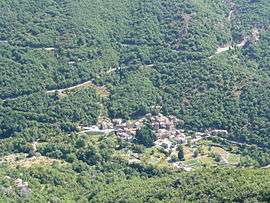
A general view of Arphy | ||
| ||
 Arphy | ||
|
Location within Occitanie region  Arphy | ||
| Coordinates: 44°01′11″N 3°35′52″E / 44.0197°N 3.5978°ECoordinates: 44°01′11″N 3°35′52″E / 44.0197°N 3.5978°E | ||
| Country | France | |
| Region | Occitanie | |
| Department | Gard | |
| Arrondissement | Le Vigan | |
| Canton | Le Vigan | |
| Intercommunality | Pays Viganais | |
| Government | ||
| • Mayor (2008–2014) | Jean-Pierre Gabel | |
| Area1 | 20.92 km2 (8.08 sq mi) | |
| Population (2008)2 | 162 | |
| • Density | 7.7/km2 (20/sq mi) | |
| Time zone | CET (UTC+1) | |
| • Summer (DST) | CEST (UTC+2) | |
| INSEE/Postal code | 30015 / 30120 | |
| Elevation |
340–1,405 m (1,115–4,610 ft) (avg. 500 m or 1,600 ft) | |
|
1 French Land Register data, which excludes lakes, ponds, glaciers > 1 km² (0.386 sq mi or 247 acres) and river estuaries. 2 Population without double counting: residents of multiple communes (e.g., students and military personnel) only counted once. | ||
.svg.png)
Arphy (Arfin in Occitan) is a commune in the Gard department in southern France.
Population
| Historical population | ||
|---|---|---|
| Year | Pop. | ±% |
| 1962 | 129 | — |
| 1968 | 130 | +0.8% |
| 1975 | 86 | −33.8% |
| 1982 | 122 | +41.9% |
| 1990 | 131 | +7.4% |
| 1999 | 173 | +32.1% |
| 2008 | 162 | −6.4% |
See also
References
| Wikimedia Commons has media related to Arphy. |
This article is issued from Wikipedia - version of the 11/6/2016. The text is available under the Creative Commons Attribution/Share Alike but additional terms may apply for the media files.