Dourbies
| Dourbies | ||
|---|---|---|
|
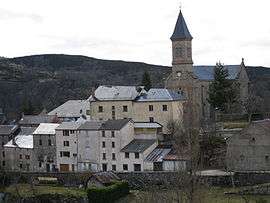
A general view of Dourbies | ||
| ||
 Dourbies | ||
|
Location within Occitanie region  Dourbies | ||
| Coordinates: 44°03′54″N 3°26′50″E / 44.065°N 3.4472°ECoordinates: 44°03′54″N 3°26′50″E / 44.065°N 3.4472°E | ||
| Country | France | |
| Region | Occitanie | |
| Department | Gard | |
| Arrondissement | Le Vigan | |
| Canton | Trèves | |
| Intercommunality | Aigoual | |
| Government | ||
| • Mayor (2001–2008) | Jacques Balsan | |
| Area1 | 60.88 km2 (23.51 sq mi) | |
| Population (2008)2 | 186 | |
| • Density | 3.1/km2 (7.9/sq mi) | |
| Time zone | CET (UTC+1) | |
| • Summer (DST) | CEST (UTC+2) | |
| INSEE/Postal code | 30105 / 30750 | |
| Elevation |
621–1,440 m (2,037–4,724 ft) (avg. 913 m or 2,995 ft) | |
|
1 French Land Register data, which excludes lakes, ponds, glaciers > 1 km² (0.386 sq mi or 247 acres) and river estuaries. 2 Population without double counting: residents of multiple communes (e.g., students and military personnel) only counted once. | ||
.svg.png)
Dourbies is a commune in the Gard department in southern France.
Population
| Historical population | ||
|---|---|---|
| Year | Pop. | ±% |
| 1962 | 233 | — |
| 1968 | 308 | +32.2% |
| 1975 | 251 | −18.5% |
| 1982 | 223 | −11.2% |
| 1990 | 213 | −4.5% |
| 1999 | 204 | −4.2% |
| 2008 | 186 | −8.8% |
See also
References
| Wikimedia Commons has media related to Dourbies. |
This article is issued from Wikipedia - version of the 11/7/2016. The text is available under the Creative Commons Attribution/Share Alike but additional terms may apply for the media files.