Pierre-Percée
For the stone arch, see Pierre Percée.
| Pierre-Percée | |
|---|---|
 Pierre-Percée | |
|
Location within Grand Est region  Pierre-Percée | |
| Coordinates: 48°28′10″N 6°55′59″E / 48.4694°N 6.9331°ECoordinates: 48°28′10″N 6°55′59″E / 48.4694°N 6.9331°E | |
| Country | France |
| Region | Grand Est |
| Department | Meurthe-et-Moselle |
| Arrondissement | Lunéville |
| Canton | Badonviller |
| Intercommunality | Vallée de la Plaine |
| Government | |
| • Mayor (2008–2014) | Jacques Boulanger |
| Area1 | 9.93 km2 (3.83 sq mi) |
| Population (1999)2 | 95 |
| • Density | 9.6/km2 (25/sq mi) |
| Time zone | CET (UTC+1) |
| • Summer (DST) | CEST (UTC+2) |
| INSEE/Postal code | 54427 / 54540 |
| Elevation | 301–2,570 m (988–8,432 ft) |
|
1 French Land Register data, which excludes lakes, ponds, glaciers > 1 km² (0.386 sq mi or 247 acres) and river estuaries. 2 Population without double counting: residents of multiple communes (e.g., students and military personnel) only counted once. | |
Pierre-Percée is a commune in the Meurthe-et-Moselle department in north-eastern France.
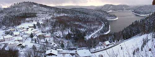
Pierre-Percée and Vieux Pré lake
Sites and monuments
- Château de Pierre-Percée ruins
- Lake of Pierre-Percée
See also
| Wikimedia Commons has media related to Pierre-Percée. |
This article is issued from Wikipedia - version of the 2/11/2016. The text is available under the Creative Commons Attribution/Share Alike but additional terms may apply for the media files.