Waville
| Waville | ||
|---|---|---|
|
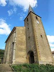
Church of Waville | ||
| ||
 Waville | ||
|
Location within Grand Est region  Waville | ||
| Coordinates: 49°00′40″N 5°57′01″E / 49.0111°N 5.9503°ECoordinates: 49°00′40″N 5°57′01″E / 49.0111°N 5.9503°E | ||
| Country | France | |
| Region | Grand Est | |
| Department | Meurthe-et-Moselle | |
| Arrondissement | Briey | |
| Canton | Chambley-Bussières | |
| Intercommunality | Communauté de communes du Mad à l'Yron | |
| Government | ||
| • Mayor (2008–2014) | Emmanuel Moussler | |
| Area1 | 11.43 km2 (4.41 sq mi) | |
| Population (1999)2 | 386 | |
| • Density | 34/km2 (87/sq mi) | |
| Time zone | CET (UTC+1) | |
| • Summer (DST) | CEST (UTC+2) | |
| INSEE/Postal code | 54593 / 54890 | |
| Elevation |
187–340 m (614–1,115 ft) (avg. 240 m or 790 ft) | |
|
1 French Land Register data, which excludes lakes, ponds, glaciers > 1 km² (0.386 sq mi or 247 acres) and river estuaries. 2 Population without double counting: residents of multiple communes (e.g., students and military personnel) only counted once. | ||

Waville is a commune in the Meurthe-et-Moselle department in north-eastern France.
Geography
The village lies on the left bank of the Rupt de Mad, which forms the commune's south-eastern border.
See also
| Wikimedia Commons has media related to Waville. |
This article is issued from Wikipedia - version of the 11/20/2014. The text is available under the Creative Commons Attribution/Share Alike but additional terms may apply for the media files.