Repaix
| Repaix | |
|---|---|
 Repaix | |
|
Location within Grand Est region  Repaix | |
| Coordinates: 48°36′31″N 6°50′01″E / 48.6086°N 6.8336°ECoordinates: 48°36′31″N 6°50′01″E / 48.6086°N 6.8336°E | |
| Country | France |
| Region | Grand Est |
| Department | Meurthe-et-Moselle |
| Arrondissement | Arrondissement of Lunéville |
| Canton | Canton of Blâmont |
| Government | |
| • Mayor (2008–2014) | Michel Marcel |
| Area1 | 4.86 km2 (1.88 sq mi) |
| Population (1999)2 | 84 |
| • Density | 17/km2 (45/sq mi) |
| Time zone | CET (UTC+1) |
| • Summer (DST) | CEST (UTC+2) |
| INSEE/Postal code | 54458 / 54450 |
| Elevation |
279–353 m (915–1,158 ft) (avg. 300 m or 980 ft) |
|
1 French Land Register data, which excludes lakes, ponds, glaciers > 1 km² (0.386 sq mi or 247 acres) and river estuaries. 2 Population without double counting: residents of multiple communes (e.g., students and military personnel) only counted once. | |
Repaix is a commune in the Meurthe-et-Moselle department in north-eastern France. In 1999, the village had 84 inhabitants.
It has an Anabaptist graveyard of the 19th century (photo).
 Coat of arms of Repaix
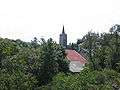 Village of Repaix
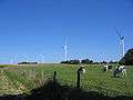 Wind turbines of Repaix
See also
| Wikimedia Commons has media related to Repaix. |
This article is issued from Wikipedia - version of the 2/11/2016. The text is available under the Creative Commons Attribution/Share Alike but additional terms may apply for the media files.