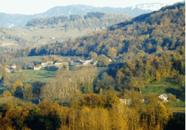
Voissant
| Voissant | |
|---|---|
 | |
 Voissant | |
|
Location within Auvergne-Rhône-Alpes region  Voissant | |
| Coordinates: 45°29′04″N 5°42′38″E / 45.4844°N 5.7106°ECoordinates: 45°29′04″N 5°42′38″E / 45.4844°N 5.7106°E | |
| Country | France |
| Region | Auvergne-Rhône-Alpes |
| Department | Isère |
| Arrondissement | La Tour-du-Pin |
| Canton | Saint-Geoire-en-Valdaine |
| Intercommunality | Pays voironnais |
| Government | |
| • Mayor (2014–2020) | Bruno Cattin |
| Area1 | 3.88 km2 (1.50 sq mi) |
| Population (2012)2 | 212 |
| • Density | 55/km2 (140/sq mi) |
| Time zone | CET (UTC+1) |
| • Summer (DST) | CEST (UTC+2) |
| INSEE/Postal code | 38564 / 38620 |
| Elevation | 269–788 m (883–2,585 ft) |
|
1 French Land Register data, which excludes lakes, ponds, glaciers > 1 km² (0.386 sq mi or 247 acres) and river estuaries. 2 Population without double counting: residents of multiple communes (e.g., students and military personnel) only counted once. | |
Voissant is a commune in the Isère department in southeastern France.
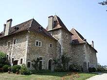
The castel of Voissant
(16th century)
(16th century)
Population
| Historical population | ||
|---|---|---|
| Year | Pop. | ±% |
| 1800 | 322 | — |
| 1806 | 358 | +11.2% |
| 1821 | 397 | +10.9% |
| 1831 | 409 | +3.0% |
| 1841 | 382 | −6.6% |
| 1851 | 334 | −12.6% |
| 1861 | 281 | −15.9% |
| 1872 | 293 | +4.3% |
| 1881 | 324 | +10.6% |
| 1891 | 331 | +2.2% |
| 1901 | 314 | −5.1% |
| 1911 | 317 | +1.0% |
| 1921 | 300 | −5.4% |
| 1931 | 276 | −8.0% |
| 1946 | 207 | −25.0% |
| 1954 | 255 | +23.2% |
| 1962 | 208 | −18.4% |
| 1968 | 218 | +4.8% |
| 1975 | 180 | −17.4% |
| 1982 | 165 | −8.3% |
| 1990 | 204 | +23.6% |
| 1999 | 208 | +2.0% |
| 2006 | 215 | +3.4% |
| 2012 | 212 | −1.4% |
See also
References
| Wikimedia Commons has media related to Voissant. |
This article is issued from Wikipedia - version of the 10/28/2016. The text is available under the Creative Commons Attribution/Share Alike but additional terms may apply for the media files.