Renage
| Renage | ||
|---|---|---|
 | ||
| ||
 Renage | ||
|
Location within Auvergne-Rhône-Alpes region  Renage | ||
| Coordinates: 45°20′03″N 5°29′10″E / 45.3342°N 5.4861°ECoordinates: 45°20′03″N 5°29′10″E / 45.3342°N 5.4861°E | ||
| Country | France | |
| Region | Auvergne-Rhône-Alpes | |
| Department | Isère | |
| Arrondissement | Grenoble | |
| Canton | Rives | |
| Intercommunality | Bièvre Est | |
| Government | ||
| • Mayor (2014–2020) | Amélie Girerd | |
| Area1 | 5.1 km2 (2.0 sq mi) | |
| Population (2011)2 | 3,682 | |
| • Density | 720/km2 (1,900/sq mi) | |
| Time zone | CET (UTC+1) | |
| • Summer (DST) | CEST (UTC+2) | |
| INSEE/Postal code | 38332 / 38140 | |
| Elevation | 229–464 m (751–1,522 ft) | |
|
1 French Land Register data, which excludes lakes, ponds, glaciers > 1 km² (0.386 sq mi or 247 acres) and river estuaries. 2 Population without double counting: residents of multiple communes (e.g., students and military personnel) only counted once. | ||

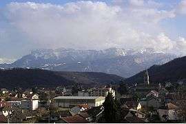
Renage is a commune in the Isère department in southeastern France.
Population
| Historical population | ||
|---|---|---|
| Year | Pop. | ±% |
| 1793 | 1,049 | — |
| 1806 | 1,146 | +9.2% |
| 1821 | 1,094 | −4.5% |
| 1831 | 1,204 | +10.1% |
| 1841 | 1,494 | +24.1% |
| 1851 | 1,630 | +9.1% |
| 1861 | 1,700 | +4.3% |
| 1872 | 1,830 | +7.6% |
| 1881 | 2,173 | +18.7% |
| 1891 | 2,330 | +7.2% |
| 1901 | 2,305 | −1.1% |
| 1911 | 2,511 | +8.9% |
| 1921 | 2,393 | −4.7% |
| 1935 | 2,468 | +3.1% |
| 1946 | 2,004 | −18.8% |
| 1954 | 2,314 | +15.5% |
| 1962 | 2,708 | +17.0% |
| 1968 | 3,037 | +12.1% |
| 1975 | 3,093 | +1.8% |
| 1982 | 3,154 | +2.0% |
| 1990 | 3,318 | +5.2% |
| 1999 | 3,332 | +0.4% |
| 2006 | 3,601 | +8.1% |
| 2011 | 3,682 | +2.2% |
See also
References
External links
| Wikimedia Commons has media related to Renage. |
This article is issued from Wikipedia - version of the 2/11/2016. The text is available under the Creative Commons Attribution/Share Alike but additional terms may apply for the media files.