Faverges-de-la-Tour
| Faverges-de-la-Tour | |
|---|---|
|
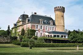
Chateau | |
 Faverges-de-la-Tour | |
|
Location within Auvergne-Rhône-Alpes region  Faverges-de-la-Tour | |
| Coordinates: 45°35′31″N 5°31′28″E / 45.5919°N 5.5244°ECoordinates: 45°35′31″N 5°31′28″E / 45.5919°N 5.5244°E | |
| Country | France |
| Region | Auvergne-Rhône-Alpes |
| Department | Isère |
| Arrondissement | La Tour-du-Pin |
| Canton | La Tour-du-Pin |
| Intercommunality | Les Vallons de La Tour du Pin |
| Government | |
| • Mayor (2014–2020) | Daniel Cézard |
| Area1 | 7.67 km2 (2.96 sq mi) |
| Population (2011)2 | 1,269 |
| • Density | 170/km2 (430/sq mi) |
| Time zone | CET (UTC+1) |
| • Summer (DST) | CEST (UTC+2) |
| INSEE/Postal code | 38162 / 38110 |
| Elevation |
285–432 m (935–1,417 ft) (avg. 394 m or 1,293 ft) |
|
1 French Land Register data, which excludes lakes, ponds, glaciers > 1 km² (0.386 sq mi or 247 acres) and river estuaries. 2 Population without double counting: residents of multiple communes (e.g., students and military personnel) only counted once. | |
Faverges-de-la-Tour is a commune in the Isère department in southeastern France.
Population
| Historical population | ||
|---|---|---|
| Year | Pop. | ±% |
| 1793 | 831 | — |
| 1806 | 919 | +10.6% |
| 1821 | 1,130 | +23.0% |
| 1831 | 1,246 | +10.3% |
| 1841 | 1,287 | +3.3% |
| 1851 | 1,264 | −1.8% |
| 1861 | 1,262 | −0.2% |
| 1982 | 1,307 | +3.6% |
| 1881 | 1,243 | −4.9% |
| 1891 | 1,205 | −3.1% |
| 1901 | 1,032 | −14.4% |
| 1911 | 902 | −12.6% |
| 1931 | 794 | −12.0% |
| 1946 | 740 | −6.8% |
| 1954 | 713 | −3.6% |
| 1962 | 720 | +1.0% |
| 1968 | 675 | −6.2% |
| 1982 | 818 | +21.2% |
| 1990 | 1,000 | +22.2% |
| 1999 | 1,107 | +10.7% |
| 2007 | 1,287 | +16.3% |
| 2011 | 1,269 | −1.4% |
See also
References
| Wikimedia Commons has media related to Faverges-de-la-Tour. |
This article is issued from Wikipedia - version of the 10/28/2016. The text is available under the Creative Commons Attribution/Share Alike but additional terms may apply for the media files.