Plieux
| Plieux | |
|---|---|
|
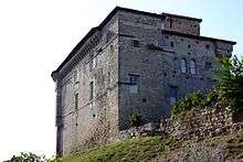
Château de Plieux | |
 Plieux | |
|
Location within Occitanie region  Plieux | |
| Coordinates: 43°57′05″N 0°44′05″E / 43.9514°N 0.7347°ECoordinates: 43°57′05″N 0°44′05″E / 43.9514°N 0.7347°E | |
| Country | France |
| Region | Occitanie |
| Department | Gers |
| Arrondissement | Condom |
| Canton | Miradoux |
| Intercommunality | Cœur de Lomagne |
| Government | |
| • Mayor (2008–2014) | Roger Sigala |
| Area1 | 12.27 km2 (4.74 sq mi) |
| Population (2008)2 | 161 |
| • Density | 13/km2 (34/sq mi) |
| Time zone | CET (UTC+1) |
| • Summer (DST) | CEST (UTC+2) |
| INSEE/Postal code | 32320 / 32340 |
| Elevation |
82–187 m (269–614 ft) (avg. 187 m or 614 ft) |
|
1 French Land Register data, which excludes lakes, ponds, glaciers > 1 km² (0.386 sq mi or 247 acres) and river estuaries. 2 Population without double counting: residents of multiple communes (e.g., students and military personnel) only counted once. | |
_Gers.jpg)
Plieux is a commune in the Gers department in southwestern France.
Geography
Localisation
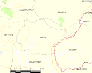
Plieux and its surrounding communes
Hydrography
The Auroue flows north through the western part of the commune; the river Arrats forms all of the commune's eastern border.
Population
| Historical population | ||
|---|---|---|
| Year | Pop. | ±% |
| 1962 | 245 | — |
| 1968 | 232 | −5.3% |
| 1975 | 214 | −7.8% |
| 1982 | 195 | −8.9% |
| 1990 | 186 | −4.6% |
| 1999 | 174 | −6.5% |
| 2008 | 161 | −7.5% |
See also
References
| Wikimedia Commons has media related to Plieux. |
This article is issued from Wikipedia - version of the 10/17/2016. The text is available under the Creative Commons Attribution/Share Alike but additional terms may apply for the media files.