Frégouville
| Frégouville | ||
|---|---|---|
| ||
 Frégouville | ||
|
Location within Occitanie region  Frégouville | ||
| Coordinates: 43°35′23″N 0°57′18″E / 43.5897°N 0.955°ECoordinates: 43°35′23″N 0°57′18″E / 43.5897°N 0.955°E | ||
| Country | France | |
| Region | Occitanie | |
| Department | Gers | |
| Arrondissement | Auch | |
| Canton | Isle-Jourdain | |
| Government | ||
| • Mayor (2008–2014) | Jean Claude Darolles | |
| Area1 | 12.32 km2 (4.76 sq mi) | |
| Population (2008)2 | 311 | |
| • Density | 25/km2 (65/sq mi) | |
| Time zone | CET (UTC+1) | |
| • Summer (DST) | CEST (UTC+2) | |
| INSEE/Postal code | 32134 / 32490 | |
| Elevation |
159–252 m (522–827 ft) (avg. 240 m or 790 ft) | |
|
1 French Land Register data, which excludes lakes, ponds, glaciers > 1 km² (0.386 sq mi or 247 acres) and river estuaries. 2 Population without double counting: residents of multiple communes (e.g., students and military personnel) only counted once. | ||
.svg.png)
Frégouville is a commune in the Gers department in southwestern France.
Geography
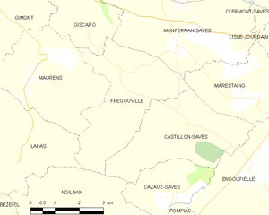
Frégouville and its surrounding communes
Population
| Historical population | ||
|---|---|---|
| Year | Pop. | ±% |
| 1962 | 232 | — |
| 1968 | 197 | −15.1% |
| 1975 | 167 | −15.2% |
| 1982 | 178 | +6.6% |
| 1990 | 191 | +7.3% |
| 1999 | 201 | +5.2% |
| 2008 | 311 | +54.7% |
See also
References
| Wikimedia Commons has media related to Frégouville. |
This article is issued from Wikipedia - version of the 8/16/2016. The text is available under the Creative Commons Attribution/Share Alike but additional terms may apply for the media files.