Saint-Aunix-Lengros
| Saint-Aunix-Lengros | |
|---|---|
 Saint-Aunix-Lengros | |
|
Location within Occitanie region  Saint-Aunix-Lengros | |
| Coordinates: 43°34′44″N 0°03′09″E / 43.5789°N 0.0525°ECoordinates: 43°34′44″N 0°03′09″E / 43.5789°N 0.0525°E | |
| Country | France |
| Region | Occitanie |
| Department | Gers |
| Arrondissement | Mirande |
| Canton | Plaisance |
| Government | |
| • Mayor (2008–2014) | Marc Lartigue |
| Area1 | 5.36 km2 (2.07 sq mi) |
| Population (2008)2 | 151 |
| • Density | 28/km2 (73/sq mi) |
| Time zone | CET (UTC+1) |
| • Summer (DST) | CEST (UTC+2) |
| INSEE/Postal code | 32362 / 32160 |
| Elevation |
131–202 m (430–663 ft) (avg. 140 m or 460 ft) |
|
1 French Land Register data, which excludes lakes, ponds, glaciers > 1 km² (0.386 sq mi or 247 acres) and river estuaries. 2 Population without double counting: residents of multiple communes (e.g., students and military personnel) only counted once. | |
Saint-Aunix-Lengros is a commune in the Gers department in southwestern France.
Geography
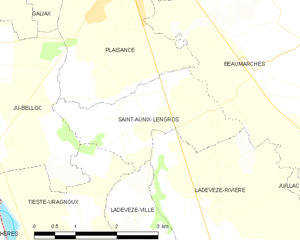
Saint-Aunix-Lengros and its surrounding communes
Population
| Historical population | ||
|---|---|---|
| Year | Pop. | ±% |
| 1962 | 170 | — |
| 1968 | 130 | −23.5% |
| 1975 | 145 | +11.5% |
| 1982 | 145 | +0.0% |
| 1990 | 146 | +0.7% |
| 1999 | 117 | −19.9% |
| 2008 | 151 | +29.1% |
See also
References
| Wikimedia Commons has media related to Saint-Aunix-Lengros. |
This article is issued from Wikipedia - version of the 11/12/2016. The text is available under the Creative Commons Attribution/Share Alike but additional terms may apply for the media files.