Flamarens
| Flamarens | |
|---|---|
|
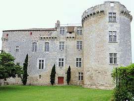
Chateau | |
 Flamarens | |
|
Location within Occitanie region  Flamarens | |
| Coordinates: 44°01′05″N 0°47′37″E / 44.0181°N 0.7936°ECoordinates: 44°01′05″N 0°47′37″E / 44.0181°N 0.7936°E | |
| Country | France |
| Region | Occitanie |
| Department | Gers |
| Arrondissement | Condom |
| Canton | Miradoux |
| Intercommunality | Lomagne Gersoise |
| Government | |
| • Mayor (2008–2014) | Xavier Ballenghien |
| Area1 | 14.36 km2 (5.54 sq mi) |
| Population (2008)2 | 117 |
| • Density | 8.1/km2 (21/sq mi) |
| Time zone | CET (UTC+1) |
| • Summer (DST) | CEST (UTC+2) |
| INSEE/Postal code | 32131 / 32340 |
| Elevation | 77–212 m (253–696 ft) |
|
1 French Land Register data, which excludes lakes, ponds, glaciers > 1 km² (0.386 sq mi or 247 acres) and river estuaries. 2 Population without double counting: residents of multiple communes (e.g., students and military personnel) only counted once. | |
Flamarens is a commune in the Gers department in southwestern France.
Geography
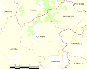
Flamarens and its surrounding communes
Population
| Historical population | ||
|---|---|---|
| Year | Pop. | ±% |
| 1962 | 227 | — |
| 1968 | 189 | −16.7% |
| 1975 | 164 | −13.2% |
| 1982 | 168 | +2.4% |
| 1990 | 145 | −13.7% |
| 1999 | 146 | +0.7% |
| 2008 | 117 | −19.9% |
See also
References
| Wikimedia Commons has media related to Flamarens. |
This article is issued from Wikipedia - version of the 7/21/2016. The text is available under the Creative Commons Attribution/Share Alike but additional terms may apply for the media files.