Tachoires
| Tachoires | |
|---|---|
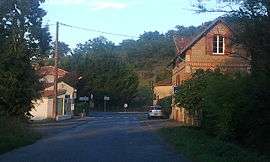 | |
 Tachoires | |
|
Location within Occitanie region  Tachoires | |
| Coordinates: 43°28′23″N 0°39′56″E / 43.4731°N 0.6656°ECoordinates: 43°28′23″N 0°39′56″E / 43.4731°N 0.6656°E | |
| Country | France |
| Region | Occitanie |
| Department | Gers |
| Arrondissement | Auch |
| Canton | Saramon |
| Intercommunality | Val de Gers |
| Government | |
| • Mayor (2014-2020) | Max Balas |
| Area1 | 9.61 km2 (3.71 sq mi) |
| Population (2008)2 | 97 |
| • Density | 10/km2 (26/sq mi) |
| Time zone | CET (UTC+1) |
| • Summer (DST) | CEST (UTC+2) |
| INSEE/Postal code | 32438 / 32260 |
| Elevation |
197–304 m (646–997 ft) (avg. 210 m or 690 ft) |
|
1 French Land Register data, which excludes lakes, ponds, glaciers > 1 km² (0.386 sq mi or 247 acres) and river estuaries. 2 Population without double counting: residents of multiple communes (e.g., students and military personnel) only counted once. | |
Tachoires is a commune in the Gers department in southwestern France.
Geography
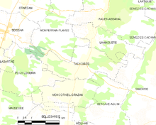
Tachoires and its surrounding communes
Government and politics
Mayors
| Mayor | Term start | Term end |
|---|---|---|
| Michel Cazaban | 2001 | 2014 |
| Max Balas | 2014 |
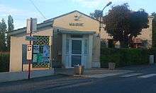
The town hall
Population
| Historical population | ||
|---|---|---|
| Year | Pop. | ±% |
| 1962 | 112 | — |
| 1968 | 106 | −5.4% |
| 1975 | 98 | −7.5% |
| 1982 | 102 | +4.1% |
| 1990 | 100 | −2.0% |
| 1999 | 101 | +1.0% |
| 2008 | 97 | −4.0% |
See also
References
| Wikimedia Commons has media related to Tachoires. |
This article is issued from Wikipedia - version of the 8/16/2016. The text is available under the Creative Commons Attribution/Share Alike but additional terms may apply for the media files.