Faget-Abbatial
| Faget-Abbatial | ||
|---|---|---|
|
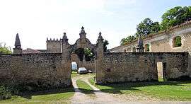
Entrance to the abbatial palace | ||
| ||
 Faget-Abbatial | ||
|
Location within Occitanie region  Faget-Abbatial | ||
| Coordinates: 43°30′25″N 0°41′41″E / 43.5069°N 0.6947°ECoordinates: 43°30′25″N 0°41′41″E / 43.5069°N 0.6947°E | ||
| Country | France | |
| Region | Occitanie | |
| Department | Gers | |
| Arrondissement | Auch | |
| Canton | Saramon | |
| Intercommunality | Val de Gers | |
| Government | ||
| • Mayor (2008–2014) | Henri Chavarot | |
| Area1 | 17.46 km2 (6.74 sq mi) | |
| Population (2008)2 | 229 | |
| • Density | 13/km2 (34/sq mi) | |
| Time zone | CET (UTC+1) | |
| • Summer (DST) | CEST (UTC+2) | |
| INSEE/Postal code | 32130 / 32450 | |
| Elevation |
182–303 m (597–994 ft) (avg. 215 m or 705 ft) | |
|
1 French Land Register data, which excludes lakes, ponds, glaciers > 1 km² (0.386 sq mi or 247 acres) and river estuaries. 2 Population without double counting: residents of multiple communes (e.g., students and military personnel) only counted once. | ||
.svg.png)
Faget-Abbatial is a commune in the Gers department in southwestern France.
Geography
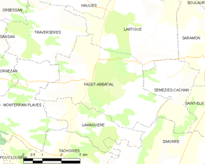
Faget-Abbatial and its surrounding communes
Population
| Historical population | ||
|---|---|---|
| Year | Pop. | ±% |
| 1962 | 278 | — |
| 1968 | 226 | −18.7% |
| 1975 | 201 | −11.1% |
| 1982 | 217 | +8.0% |
| 1990 | 201 | −7.4% |
| 1999 | 211 | +5.0% |
| 2008 | 229 | +8.5% |
See also
References
| Wikimedia Commons has media related to Faget-Abbatial. |
This article is issued from Wikipedia - version of the 2/26/2016. The text is available under the Creative Commons Attribution/Share Alike but additional terms may apply for the media files.