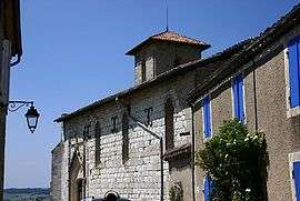
Castéra-Lectourois
| Castéra-Lectourois | |
|---|---|
 | |
 Castéra-Lectourois | |
|
Location within Occitanie region  Castéra-Lectourois | |
| Coordinates: 43°58′35″N 0°36′38″E / 43.9764°N 0.6106°ECoordinates: 43°58′35″N 0°36′38″E / 43.9764°N 0.6106°E | |
| Country | France |
| Region | Occitanie |
| Department | Gers |
| Arrondissement | Condom |
| Canton | Lectoure |
| Intercommunality | Lomagne Gersoise |
| Government | |
| • Mayor (2008–2014) | Guy Verdier |
| Area1 | 18.86 km2 (7.28 sq mi) |
| Population (2008)2 | 298 |
| • Density | 16/km2 (41/sq mi) |
| Time zone | CET (UTC+1) |
| • Summer (DST) | CEST (UTC+2) |
| INSEE/Postal code | 32082 / 32700 |
| Elevation |
64–203 m (210–666 ft) (avg. 260 m or 850 ft) |
|
1 French Land Register data, which excludes lakes, ponds, glaciers > 1 km² (0.386 sq mi or 247 acres) and river estuaries. 2 Population without double counting: residents of multiple communes (e.g., students and military personnel) only counted once. | |
Castéra-Lectourois is a commune in the Gers department in southwestern France.
Geography
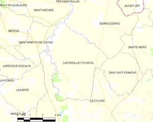
Castéra-Lectourois and its surrounding communes
Population
| Historical population | ||
|---|---|---|
| Year | Pop. | ±% |
| 1962 | 382 | — |
| 1968 | 307 | −19.6% |
| 1975 | 245 | −20.2% |
| 1982 | 223 | −9.0% |
| 1990 | 241 | +8.1% |
| 1999 | 296 | +22.8% |
| 2008 | 298 | +0.7% |
See also
References
| Wikimedia Commons has media related to Castéra-Lectourois. |
This article is issued from Wikipedia - version of the 2/3/2016. The text is available under the Creative Commons Attribution/Share Alike but additional terms may apply for the media files.