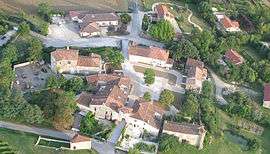
Maignaut-Tauzia
| Maignaut-Tauzia | |
|---|---|
 | |
 Maignaut-Tauzia | |
|
Location within Occitanie region  Maignaut-Tauzia | |
| Coordinates: 43°53′26″N 0°24′26″E / 43.8906°N 0.4072°ECoordinates: 43°53′26″N 0°24′26″E / 43.8906°N 0.4072°E | |
| Country | France |
| Region | Occitanie |
| Department | Gers |
| Arrondissement | Condom |
| Canton | Valence-sur-Baïse |
| Government | |
| • Mayor (2008–2014) | Francis Dupouy |
| Area1 | 11.14 km2 (4.30 sq mi) |
| Population (2008)2 | 217 |
| • Density | 19/km2 (50/sq mi) |
| Time zone | CET (UTC+1) |
| • Summer (DST) | CEST (UTC+2) |
| INSEE/Postal code | 32224 / 32310 |
| Elevation |
75–193 m (246–633 ft) (avg. 150 m or 490 ft) |
|
1 French Land Register data, which excludes lakes, ponds, glaciers > 1 km² (0.386 sq mi or 247 acres) and river estuaries. 2 Population without double counting: residents of multiple communes (e.g., students and military personnel) only counted once. | |
Maignaut-Tauzia is a commune in the Gers department in southwestern France.
Geography
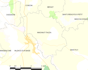
Maignaut-Tauzia and its surrounding communes
Population
| Historical population | ||
|---|---|---|
| Year | Pop. | ±% |
| 1846 | 453 | — |
| 1896 | 265 | −41.5% |
| 1911 | 260 | −1.9% |
| 1926 | 231 | −11.2% |
| 1939 | 216 | −6.5% |
| 1947 | 241 | +11.6% |
| 1962 | 154 | −36.1% |
| 1968 | 169 | +9.7% |
| 1975 | 142 | −16.0% |
| 1982 | 142 | +0.0% |
| 1990 | 195 | +37.3% |
| 1999 | 181 | −7.2% |
| 2008 | 217 | +19.9% |
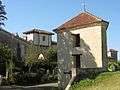 Dovecote and town gate
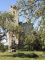 Château du Tauzia
See also
References
External links
| Wikimedia Commons has media related to Maignaut-Tauzia. |
This article is issued from Wikipedia - version of the 8/16/2016. The text is available under the Creative Commons Attribution/Share Alike but additional terms may apply for the media files.