Pancé
| Pancé Pantieg | |
|---|---|
|
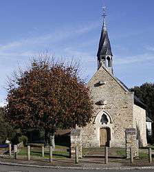
The chapel of Saint-Melaine | |
 Pancé | |
|
Location within Brittany region  Pancé | |
| Coordinates: 47°52′56″N 1°39′25″W / 47.8822°N 1.6569°WCoordinates: 47°52′56″N 1°39′25″W / 47.8822°N 1.6569°W | |
| Country | France |
| Region | Brittany |
| Department | Ille-et-Vilaine |
| Arrondissement | Redon |
| Canton | Bain-de-Bretagne |
| Intercommunality | Moyenne Vilaine et du Semnon |
| Government | |
| • Mayor (2014–2020) | Jean-Marie Princen |
| Area1 | 19.33 km2 (7.46 sq mi) |
| Population (2008)2 | 1,124 |
| • Density | 58/km2 (150/sq mi) |
| Time zone | CET (UTC+1) |
| • Summer (DST) | CEST (UTC+2) |
| INSEE/Postal code | 35212 / 35320 |
| Elevation | 17–105 m (56–344 ft) |
|
1 French Land Register data, which excludes lakes, ponds, glaciers > 1 km² (0.386 sq mi or 247 acres) and river estuaries. 2 Population without double counting: residents of multiple communes (e.g., students and military personnel) only counted once. | |
Pancé (Breton: Pantieg, Gallo: Panczaé) is a commune in the Ille-et-Vilaine department of Brittany in northwestern France.
Geography
The river Semnon forms all of the commune's southern border.
Population
Inhabitants of Pancé are called Pancéens in French.
| Historical population | ||
|---|---|---|
| Year | Pop. | ±% |
| 1962 | 669 | — |
| 1968 | 725 | +8.4% |
| 1975 | 689 | −5.0% |
| 1982 | 763 | +10.7% |
| 1990 | 794 | +4.1% |
| 1999 | 964 | +21.4% |
| 2008 | 1,124 | +16.6% |
See also
References
External links
| Wikimedia Commons has media related to Pancé. |
This article is issued from Wikipedia - version of the 7/11/2016. The text is available under the Creative Commons Attribution/Share Alike but additional terms may apply for the media files.