Saint-Christophe-de-Valains
| Saint-Christophe-de-Valains Sant-Kristol-Gwalen | |
|---|---|
|
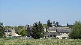
A general view of Saint-Christophe-de-Valains | |
 Saint-Christophe-de-Valains | |
|
Location within Brittany region  Saint-Christophe-de-Valains | |
| Coordinates: 48°20′37″N 1°26′46″W / 48.3436°N 1.4461°WCoordinates: 48°20′37″N 1°26′46″W / 48.3436°N 1.4461°W | |
| Country | France |
| Region | Brittany |
| Department | Ille-et-Vilaine |
| Arrondissement | Fougères-Vitré |
| Canton | Saint-Aubin-du-Cormier |
| Intercommunality | Pays de Saint-Aubin-du-Cormier |
| Government | |
| • Mayor (2014–2020) | Yves Gérard |
| Area1 | 3.27 km2 (1.26 sq mi) |
| Population (2009)2 | 211 |
| • Density | 65/km2 (170/sq mi) |
| Time zone | CET (UTC+1) |
| • Summer (DST) | CEST (UTC+2) |
| INSEE/Postal code | 35261 / 35140 |
| Elevation |
35–104 m (115–341 ft) (avg. 75 m or 246 ft) |
|
1 French Land Register data, which excludes lakes, ponds, glaciers > 1 km² (0.386 sq mi or 247 acres) and river estuaries. 2 Population without double counting: residents of multiple communes (e.g., students and military personnel) only counted once. | |
Saint-Christophe-de-Valains (Breton: Sant-Kristol-Gwalen) is a commune in the Ille-et-Vilaine department in Brittany in northwestern France.
Saint-Christophe-de-Valains comes from Saint Christopher, patron saint of travelers and Valains, fief of Vieux-Vy-sur-Couesnon.
Population
| Historical population | ||
|---|---|---|
| Year | Pop. | ±% |
| 1793 | 235 | — |
| 1800 | 295 | +25.5% |
| 1806 | 260 | −11.9% |
| 1821 | 257 | −1.2% |
| 1831 | 286 | +11.3% |
| 1836 | 308 | +7.7% |
| 1841 | 290 | −5.8% |
| 1846 | 296 | +2.1% |
| 1851 | 323 | +9.1% |
| 1856 | 310 | −4.0% |
| 1861 | 300 | −3.2% |
| 1866 | 341 | +13.7% |
| 1872 | 324 | −5.0% |
| 1876 | 324 | +0.0% |
| 1881 | 321 | −0.9% |
| 1886 | 300 | −6.5% |
| 1891 | 324 | +8.0% |
| 1896 | 291 | −10.2% |
| 1901 | 274 | −5.8% |
| 1906 | 291 | +6.2% |
| 1911 | 223 | −23.4% |
| 1921 | 193 | −13.5% |
| 1926 | 241 | +24.9% |
| 1931 | 222 | −7.9% |
| 1936 | 232 | +4.5% |
| 1946 | 194 | −16.4% |
| 1954 | 185 | −4.6% |
| 1962 | 164 | −11.4% |
| 1968 | 151 | −7.9% |
| 1975 | 129 | −14.6% |
| 1982 | 107 | −17.1% |
| 1990 | 106 | −0.9% |
| 1999 | 138 | +30.2% |
| 2009 | 211 | +52.9% |
Geography
Saint-Christophe-de-Valains is located at 37 km (23 mi) in the North-East of Rennes and at 35 km (22 mi) in the south of the Mont Saint-Michel.
The neighboring communes are Chauvigné, Le Tiercent, Saint-Ouen-des-Alleux, and Vieux-Vy-sur-Couesnon.
Sights
- Parish Church of the 15th century.
- Castle of La Bélinaye 17th century.
- Liberty Oak in La Basse-Haye.
- Valley of "La Minette".
_Mairie.jpg) Town hall of Saint-Christophe-de-Valains.
Town hall of Saint-Christophe-de-Valains.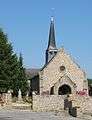 Church of Saint-Christophe-de-Valains
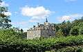 Castle of La Bélinaye 17th century.
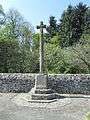 The war memorial.
_Ch%C3%AAne_de_la_Libert%C3%A9_01.jpg) The Liberty Oak.
The Liberty Oak. Saint-Christophe-de-Valains
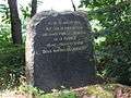 Memorial stone.
 Flood of January 4, 1936.
Events
Ball every 14 July under the Liberty Oak.
See also
References
External links
| Wikimedia Commons has media related to Saint-Christophe-de-Valains. |
- Official website : Saint-Christophe-de-Valains (French)
- fr:Saint-Christophe-de-Valains
- Geography of Brittany
- A history of local French Resistance during the World War II.
- The page of the commune on infobretagne.com
- The data base Mérimée - the French architectural heritage
This article is issued from Wikipedia - version of the 11/6/2015. The text is available under the Creative Commons Attribution/Share Alike but additional terms may apply for the media files.