Landéan
| Landéan Landean | |
|---|---|
|
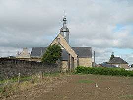
The church of Saint-Pierre | |
 Landéan | |
|
Location within Brittany region  Landéan | |
| Coordinates: 48°24′50″N 1°09′05″W / 48.4139°N 1.1514°WCoordinates: 48°24′50″N 1°09′05″W / 48.4139°N 1.1514°W | |
| Country | France |
| Region | Brittany |
| Department | Ille-et-Vilaine |
| Arrondissement | Fougères-Vitré |
| Canton | Fougères-Nord |
| Intercommunality | Fougères |
| Government | |
| • Mayor (2014–2020) | Louis-Gérard Guérin |
| Area1 | 27.31 km2 (10.54 sq mi) |
| Population (2008)2 | 1,253 |
| • Density | 46/km2 (120/sq mi) |
| Time zone | CET (UTC+1) |
| • Summer (DST) | CEST (UTC+2) |
| INSEE/Postal code | 35142 / 35133 |
| Elevation | 107–208 m (351–682 ft) |
|
1 French Land Register data, which excludes lakes, ponds, glaciers > 1 km² (0.386 sq mi or 247 acres) and river estuaries. 2 Population without double counting: residents of multiple communes (e.g., students and military personnel) only counted once. | |
Landéan (Breton: Landean) is a commune in the Ille-et-Vilaine department of Brittany in northwestern France.
Population
Inhabitants of Landéan are called in French landéanais .
| Historical population | ||
|---|---|---|
| Year | Pop. | ±% |
| 1962 | 865 | — |
| 1968 | 917 | +6.0% |
| 1975 | 920 | +0.3% |
| 1982 | 1,129 | +22.7% |
| 1990 | 1,199 | +6.2% |
| 1999 | 1,166 | −2.8% |
| 2008 | 1,253 | +7.5% |
See also
References
External links
| Wikimedia Commons has media related to Landéan. |
This article is issued from Wikipedia - version of the 2/12/2016. The text is available under the Creative Commons Attribution/Share Alike but additional terms may apply for the media files.