Rétaud
| Rétaud | |
|---|---|
|
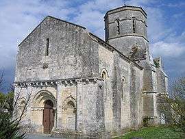
Romanesque church | |
 Rétaud | |
|
Location within Nouvelle-Aquitaine region  Rétaud | |
| Coordinates: 45°40′41″N 0°43′38″W / 45.6781°N 0.7272°WCoordinates: 45°40′41″N 0°43′38″W / 45.6781°N 0.7272°W | |
| Country | France |
| Region | Nouvelle-Aquitaine |
| Department | Charente-Maritime |
| Arrondissement | Saintes |
| Canton | Gémozac |
| Intercommunality | Canton de Gémozac et Saintonge Viticole |
| Government | |
| • Mayor (2008–2014) | Michel Pelletier |
| Area1 | 19.92 km2 (7.69 sq mi) |
| Population (2008)2 | 957 |
| • Density | 48/km2 (120/sq mi) |
| Time zone | CET (UTC+1) |
| • Summer (DST) | CEST (UTC+2) |
| INSEE/Postal code | 17296 / 17460 |
| Elevation | 26–49 m (85–161 ft) |
|
1 French Land Register data, which excludes lakes, ponds, glaciers > 1 km² (0.386 sq mi or 247 acres) and river estuaries. 2 Population without double counting: residents of multiple communes (e.g., students and military personnel) only counted once. | |
Rétaud is a commune in the Charente-Maritime department in southwestern France.
Population
| Historical population | ||
|---|---|---|
| Year | Pop. | ±% |
| 1962 | 745 | — |
| 1968 | 739 | −0.8% |
| 1975 | 650 | −12.0% |
| 1982 | 740 | +13.8% |
| 1990 | 805 | +8.8% |
| 1999 | 869 | +8.0% |
| 2009 | 957 | +10.1% |
See also
References
| Wikimedia Commons has media related to Rétaud. |
This article is issued from Wikipedia - version of the 3/8/2013. The text is available under the Creative Commons Attribution/Share Alike but additional terms may apply for the media files.