Broindon
| Broindon | ||
|---|---|---|
|
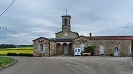
Town hall | ||
| ||
 Broindon | ||
|
Location within Bourgogne-Franche-Comté region  Broindon | ||
| Coordinates: 47°11′54″N 5°02′43″E / 47.1983°N 5.0453°E / 47.1983; 5.0453Coordinates: 47°11′54″N 5°02′43″E / 47.1983°N 5.0453°E / 47.1983; 5.0453 | ||
| Country | France | |
| Region | Bourgogne-Franche-Comté | |
| Department | Côte-d'Or | |
| Arrondissement | Dijon | |
| Canton | Gevrey-Chambertin | |
| Intercommunality | Sud Dijonnais | |
| Government | ||
| • Mayor (2008–2014) | Marylène Bobrowski | |
| Area1 | 4.64 km2 (1.79 sq mi) | |
| Population (2008)2 | 90 | |
| • Density | 19/km2 (50/sq mi) | |
| Time zone | CET (UTC+1) | |
| • Summer (DST) | CEST (UTC+2) | |
| INSEE/Postal code | 21113 / 21220 | |
| Elevation | 206–226 m (676–741 ft) | |
|
1 French Land Register data, which excludes lakes, ponds, glaciers > 1 km² (0.386 sq mi or 247 acres) and river estuaries. 2 Population without double counting: residents of multiple communes (e.g., students and military personnel) only counted once. | ||

Broindon is a commune in the Côte-d'Or department in eastern France.
Population
| Historical population | ||
|---|---|---|
| Year | Pop. | ±% |
| 1962 | 30 | — |
| 1968 | 41 | +36.7% |
| 1975 | 42 | +2.4% |
| 1982 | 62 | +47.6% |
| 1990 | 71 | +14.5% |
| 1999 | 61 | −14.1% |
| 2008 | 90 | +47.5% |
See also
References
| Wikimedia Commons has media related to Broindon. |
This article is issued from Wikipedia - version of the 9/17/2015. The text is available under the Creative Commons Attribution/Share Alike but additional terms may apply for the media files.