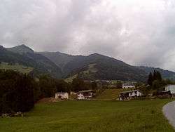
Thüringerberg
| Thüringerberg | ||
|---|---|---|
 | ||
| ||
 Thüringerberg Location within Austria | ||
Location in the district
| ||
| Coordinates: 47°12′54″N 09°46′59″E / 47.21500°N 9.78306°ECoordinates: 47°12′54″N 09°46′59″E / 47.21500°N 9.78306°E | ||
| Country | Austria | |
| State | Vorarlberg | |
| District | Bludenz | |
| Government | ||
| • Mayor | Wilhelm Müller | |
| Area | ||
| • Total | 10.39 km2 (4.01 sq mi) | |
| Elevation | 877 m (2,877 ft) | |
| Population (1 January 2016)[1] | ||
| • Total | 710 | |
| • Density | 68/km2 (180/sq mi) | |
| Time zone | CET (UTC+1) | |
| • Summer (DST) | CEST (UTC+2) | |
| Postal code | 6721 | |
| Area code | 05550 | |
| Vehicle registration | BZ | |
| Website | www.thueringerberg.at | |

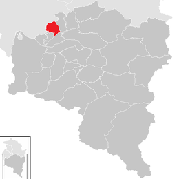
Thüringerberg is a municipality in the district of Bludenz in the Austrian state of Vorarlberg.
Population
| Historical population | ||
|---|---|---|
| Year | Pop. | ±% |
| 1869 | 325 | — |
| 1880 | 309 | −4.9% |
| 1890 | 395 | +27.8% |
| 1900 | 282 | −28.6% |
| 1910 | 309 | +9.6% |
| 1923 | 344 | +11.3% |
| 1934 | 350 | +1.7% |
| 1939 | 379 | +8.3% |
| 1951 | 411 | +8.4% |
| 1961 | 432 | +5.1% |
| 1971 | 478 | +10.6% |
| 1981 | 562 | +17.6% |
| 1991 | 653 | +16.2% |
| 2001 | 667 | +2.1% |
| 2011 | 681 | +2.1% |
References
| Wikimedia Commons has media related to Thüringerberg. |
This article is issued from Wikipedia - version of the 7/21/2015. The text is available under the Creative Commons Attribution/Share Alike but additional terms may apply for the media files.