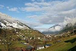
Gaschurn
| Gaschurn | ||
|---|---|---|
 | ||
| ||
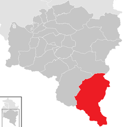
 Gaschurn Location within Austria | ||
Location in the district
| ||
| Coordinates: 46°58′00″N 10°01′00″E / 46.96667°N 10.01667°ECoordinates: 46°58′00″N 10°01′00″E / 46.96667°N 10.01667°E | ||
| Country | Austria | |
| State | Vorarlberg | |
| District | Bludenz | |
| Government | ||
| • Mayor | Martin Netzer | |
| Area | ||
| • Total | 176.78 km2 (68.26 sq mi) | |
| Elevation | 979 m (3,212 ft) | |
| Population (1 January 2016)[1] | ||
| • Total | 1,468 | |
| • Density | 8.3/km2 (22/sq mi) | |
| Time zone | CET (UTC+1) | |
| • Summer (DST) | CEST (UTC+2) | |
| Postal code | 6793 | |
| Area code | 05558 | |
| Vehicle registration | BZ | |
| Website |
www.riskommunal.net/ gaschurn | |


Church (die katholische Pfarrkirche heilige Michael) in the street
Gaschurn (High Alemannic: Kaschore) is a municipality in the district of Bludenz in the Austrian state of Vorarlberg.
Population
| Historical population | ||
|---|---|---|
| Year | Pop. | ±% |
| 1869 | 1,101 | — |
| 1880 | 954 | −13.4% |
| 1890 | 934 | −2.1% |
| 1900 | 866 | −7.3% |
| 1910 | 828 | −4.4% |
| 1923 | 807 | −2.5% |
| 1934 | 1,229 | +52.3% |
| 1939 | 1,501 | +22.1% |
| 1951 | 1,660 | +10.6% |
| 1961 | 1,750 | +5.4% |
| 1971 | 1,710 | −2.3% |
| 1981 | 1,691 | −1.1% |
| 1991 | 1,714 | +1.4% |
| 2001 | 1,651 | −3.7% |
| 2011 | 1,529 | −7.4% |
References
| Wikimedia Commons has media related to Gaschurn. |
This article is issued from Wikipedia - version of the 11/11/2016. The text is available under the Creative Commons Attribution/Share Alike but additional terms may apply for the media files.