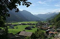
Schnepfau
| Schnepfau | ||
|---|---|---|
 | ||
| ||
 Schnepfau Location within Austria | ||
Location in the district
| ||
| Coordinates: 47°21′00″N 09°56′00″E / 47.35000°N 9.93333°ECoordinates: 47°21′00″N 09°56′00″E / 47.35000°N 9.93333°E | ||
| Country | Austria | |
| State | Vorarlberg | |
| District | Bregenz | |
| Government | ||
| • Mayor | Josef Moosbrugger | |
| Area | ||
| • Total | 16.53 km2 (6.38 sq mi) | |
| Elevation | 734 m (2,408 ft) | |
| Population (1 January 2016)[1] | ||
| • Total | 465 | |
| • Density | 28/km2 (73/sq mi) | |
| Time zone | CET (UTC+1) | |
| • Summer (DST) | CEST (UTC+2) | |
| Postal code | 6882 | |
| Area code | 05518 | |
| Vehicle registration | B | |
| Website | www.schnepfau.at | |
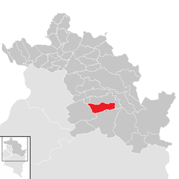
Schnepfau is a municipality in the district of Bregenz in the Austrian state of Vorarlberg.
Population
| Historical population | ||
|---|---|---|
| Year | Pop. | ±% |
| 1869 | 409 | — |
| 1880 | 360 | −12.0% |
| 1890 | 346 | −3.9% |
| 1900 | 291 | −15.9% |
| 1910 | 302 | +3.8% |
| 1923 | 315 | +4.3% |
| 1934 | 339 | +7.6% |
| 1939 | 329 | −2.9% |
| 1951 | 406 | +23.4% |
| 1961 | 378 | −6.9% |
| 1971 | 339 | −10.3% |
| 1981 | 373 | +10.0% |
| 1991 | 432 | +15.8% |
| 2001 | 483 | +11.8% |
| 2011 | 473 | −2.1% |
References
| Wikimedia Commons has media related to Schnepfau. |
This article is issued from Wikipedia - version of the 5/20/2015. The text is available under the Creative Commons Attribution/Share Alike but additional terms may apply for the media files.