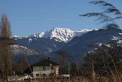
Meiningen, Austria
| Meiningen | ||
|---|---|---|
 | ||
| ||
 Meiningen Location within Austria | ||
Location in the district
| ||
| Coordinates: 47°18′00″N 09°35′00″E / 47.30000°N 9.58333°ECoordinates: 47°18′00″N 09°35′00″E / 47.30000°N 9.58333°E | ||
| Country | Austria | |
| State | Vorarlberg | |
| District | Feldkirch | |
| Government | ||
| • Mayor | Thomas Pinter | |
| Area | ||
| • Total | 5.37 km2 (2.07 sq mi) | |
| Elevation | 425 m (1,394 ft) | |
| Population (1 January 2016)[1] | ||
| • Total | 2,148 | |
| • Density | 400/km2 (1,000/sq mi) | |
| Time zone | CET (UTC+1) | |
| • Summer (DST) | CEST (UTC+2) | |
| Postal code | 6812 | |
| Area code | 05522 | |
| Vehicle registration | FK | |
| Website | www.meiningen.at | |

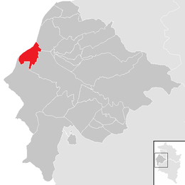
Meiningen is a municipality in the district of Feldkirch in the Austrian state of Vorarlberg.
Population
| Historical population | ||
|---|---|---|
| Year | Pop. | ±% |
| 1869 | 400 | — |
| 1880 | 412 | +3.0% |
| 1890 | 429 | +4.1% |
| 1900 | 419 | −2.3% |
| 1910 | 448 | +6.9% |
| 1923 | 459 | +2.5% |
| 1934 | 479 | +4.4% |
| 1939 | 447 | −6.7% |
| 1951 | 563 | +26.0% |
| 1961 | 672 | +19.4% |
| 1971 | 981 | +46.0% |
| 1981 | 1,284 | +30.9% |
| 1991 | 1,590 | +23.8% |
| 2001 | 1,872 | +17.7% |
| 2011 | 2,014 | +7.6% |
References
| Wikimedia Commons has media related to Meiningen (Vorarlberg). |
This article is issued from Wikipedia - version of the 6/22/2015. The text is available under the Creative Commons Attribution/Share Alike but additional terms may apply for the media files.