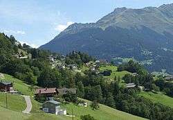
Bartholomäberg
| Bartholomäberg | ||
|---|---|---|
 | ||
| ||
 Bartholomäberg Location within Austria | ||
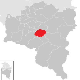
Location in the district
| ||
| Coordinates: 47°05′N 09°54′E / 47.083°N 9.900°ECoordinates: 47°05′N 09°54′E / 47.083°N 9.900°E | ||
| Country | Austria | |
| State | Vorarlberg | |
| District | Bludenz | |
| Government | ||
| • Mayor | Martin Vallaster | |
| Area | ||
| • Total | 27.28 km2 (10.53 sq mi) | |
| Elevation | 1,087 m (3,566 ft) | |
| Population (1 January 2016)[1] | ||
| • Total | 2,327 | |
| • Density | 85/km2 (220/sq mi) | |
| Time zone | CET (UTC+1) | |
| • Summer (DST) | CEST (UTC+2) | |
| Postal code | 6781 | |
| Website | http://www.bartholomaeberg.at | |
Bartholomäberg (High Alemannic: Bèèrg) is a municipality and popular tourism resort in the district of Bludenz in the Austrian state of Vorarlberg.
Population
| Historical population | ||
|---|---|---|
| Year | Pop. | ±% |
| 1869 | 1,197 | — |
| 1880 | 1,211 | +1.2% |
| 1890 | 1,119 | −7.6% |
| 1900 | 997 | −10.9% |
| 1910 | 1,003 | +0.6% |
| 1923 | 1,038 | +3.5% |
| 1934 | 1,132 | +9.1% |
| 1939 | 1,125 | −0.6% |
| 1951 | 1,368 | +21.6% |
| 1961 | 1,553 | +13.5% |
| 1971 | 1,792 | +15.4% |
| 1981 | 2,001 | +11.7% |
| 1991 | 2,137 | +6.8% |
| 2001 | 2,233 | +4.5% |
| 2011 | 2,262 | +1.3% |
References
| Wikimedia Commons has media related to Bartholomäberg. |
This article is issued from Wikipedia - version of the 11/11/2016. The text is available under the Creative Commons Attribution/Share Alike but additional terms may apply for the media files.