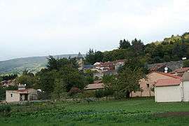
Courniou
| Courniou | ||
|---|---|---|
|
View | ||
| ||
 Courniou | ||
|
Location within Occitanie region  Courniou | ||
| Coordinates: 43°28′28″N 2°42′45″E / 43.4744°N 2.7125°ECoordinates: 43°28′28″N 2°42′45″E / 43.4744°N 2.7125°E | ||
| Country | France | |
| Region | Occitanie | |
| Department | Hérault | |
| Arrondissement | Béziers | |
| Canton | Saint-Pons-de-Thomières | |
| Intercommunality | Pays Saint-Ponais | |
| Government | ||
| • Mayor (2008–2014) | Jean-Pierre Rouanet | |
| Area1 | 30.06 km2 (11.61 sq mi) | |
| Population (2008)2 | 620 | |
| • Density | 21/km2 (53/sq mi) | |
| Time zone | CET (UTC+1) | |
| • Summer (DST) | CEST (UTC+2) | |
| INSEE/Postal code | 34086 / 34220 | |
| Elevation |
329–951 m (1,079–3,120 ft) (avg. 362 m or 1,188 ft) | |
|
1 French Land Register data, which excludes lakes, ponds, glaciers > 1 km² (0.386 sq mi or 247 acres) and river estuaries. 2 Population without double counting: residents of multiple communes (e.g., students and military personnel) only counted once. | ||
.svg.png)
Courniou is a commune in the Hérault department in southern France.
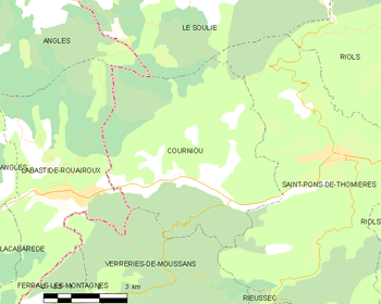
Map
Population
| Historical population | ||
|---|---|---|
| Year | Pop. | ±% |
| 1962 | 385 | — |
| 1968 | 529 | +37.4% |
| 1975 | 503 | −4.9% |
| 1982 | 537 | +6.8% |
| 1990 | 595 | +10.8% |
| 1999 | 606 | +1.8% |
| 2008 | 620 | +2.3% |
See also
References
| Wikimedia Commons has media related to Courniou. |
This article is issued from Wikipedia - version of the 4/30/2014. The text is available under the Creative Commons Attribution/Share Alike but additional terms may apply for the media files.