Mutrécy
| Mutrécy | |
|---|---|
|
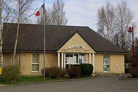
Town hall | |
 Mutrécy | |
|
Location within Normandy region  Mutrécy | |
| Coordinates: 49°03′51″N 0°25′15″W / 49.0642°N 0.4208°WCoordinates: 49°03′51″N 0°25′15″W / 49.0642°N 0.4208°W | |
| Country | France |
| Region | Normandy |
| Department | Calvados |
| Arrondissement | Caen |
| Canton | Bretteville-sur-Laize |
| Intercommunality | Suisse Normande |
| Government | |
| • Mayor (2008–2014) | Gérard Valentin |
| Area1 | 6.71 km2 (2.59 sq mi) |
| Population (2008)2 | 329 |
| • Density | 49/km2 (130/sq mi) |
| Time zone | CET (UTC+1) |
| • Summer (DST) | CEST (UTC+2) |
| INSEE/Postal code | 14461 / 14220 |
| Elevation |
7–104 m (23–341 ft) (avg. 85 m or 279 ft) |
|
1 French Land Register data, which excludes lakes, ponds, glaciers > 1 km² (0.386 sq mi or 247 acres) and river estuaries. 2 Population without double counting: residents of multiple communes (e.g., students and military personnel) only counted once. | |
Mutrécy is a commune in the Calvados department in the Normandy region in northwestern France.
Population
| Historical population | ||
|---|---|---|
| Year | Pop. | ±% |
| 1962 | 203 | — |
| 1968 | 189 | −6.9% |
| 1975 | 207 | +9.5% |
| 1982 | 216 | +4.3% |
| 1990 | 219 | +1.4% |
| 1999 | 266 | +21.5% |
| 2008 | 329 | +23.7% |
See also
References
Gallery
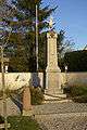 War memorial
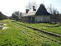 Station platforms
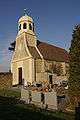 11th century church of Saint-Clair
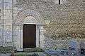 Side door of church
| Wikimedia Commons has media related to Mutrécy. |
This article is issued from Wikipedia - version of the 3/16/2016. The text is available under the Creative Commons Attribution/Share Alike but additional terms may apply for the media files.