Curemonte
| Curemonte | ||
|---|---|---|
|
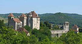
The Château des Plas, in Curemonte | ||
| ||
 Curemonte | ||
|
Location within Nouvelle-Aquitaine region  Curemonte | ||
| Coordinates: 45°00′00″N 1°44′27″E / 44.9999°N 1.7409°ECoordinates: 45°00′00″N 1°44′27″E / 44.9999°N 1.7409°E | ||
| Country | France | |
| Region | Nouvelle-Aquitaine | |
| Department | Corrèze | |
| Arrondissement | Brive-la-Gaillarde | |
| Canton | Meyssac | |
| Intercommunality | Villages du Midi Corrézien | |
| Government | ||
| • Mayor (2001–2008) | Jean-Claude Raynal | |
| Area1 | 8.83 km2 (3.41 sq mi) | |
| Population (2008)2 | 213 | |
| • Density | 24/km2 (62/sq mi) | |
| Time zone | CET (UTC+1) | |
| • Summer (DST) | CEST (UTC+2) | |
| INSEE/Postal code | 19067 / 19500 | |
|
1 French Land Register data, which excludes lakes, ponds, glaciers > 1 km² (0.386 sq mi or 247 acres) and river estuaries. 2 Population without double counting: residents of multiple communes (e.g., students and military personnel) only counted once. | ||
.svg.png)
Curemonte is a commune in the Corrèze department in central France.
It is a medieval village characterised by its three castles. In a fortified position on a ridge overlooking a valley on both its eastern and western flanks, the village has historically had a strategic importance in the area.
Population
| Historical population | ||
|---|---|---|
| Year | Pop. | ±% |
| 1962 | 351 | — |
| 1968 | 311 | −11.4% |
| 1975 | 248 | −20.3% |
| 1982 | 231 | −6.9% |
| 1990 | 203 | −12.1% |
| 1999 | 223 | +9.9% |
| 2008 | 213 | −4.5% |
See also
References
| Wikimedia Commons has media related to Curemonte. |
This article is issued from Wikipedia - version of the 2/26/2015. The text is available under the Creative Commons Attribution/Share Alike but additional terms may apply for the media files.