Baudrières
| Baudrières | |
|---|---|
|
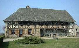
Typical old Bresse farmhouse | |
 Baudrières | |
|
Location within Bourgogne-Franche-Comté region  Baudrières | |
| Coordinates: 46°40′29″N 5°00′48″E / 46.6747°N 5.0133°ECoordinates: 46°40′29″N 5°00′48″E / 46.6747°N 5.0133°E | |
| Country | France |
| Region | Bourgogne-Franche-Comté |
| Department | Saône-et-Loire |
| Arrondissement | Chalon-sur-Saône |
| Canton | Saint-Germain-du-Plain |
| Intercommunality | Portes de la Bresse |
| Area1 | 27 km2 (10 sq mi) |
| Population (2012)2 | 917 |
| • Density | 34/km2 (88/sq mi) |
| Time zone | CET (UTC+1) |
| • Summer (DST) | CEST (UTC+2) |
| INSEE/Postal code | 71023 / 71370 |
| Elevation |
172–216 m (564–709 ft) (avg. 194 m or 636 ft) |
|
1 French Land Register data, which excludes lakes, ponds, glaciers > 1 km² (0.386 sq mi or 247 acres) and river estuaries. 2 Population without double counting: residents of multiple communes (e.g., students and military personnel) only counted once. | |
Baudrières is a commune in the Saône-et-Loire department in the region of Bourgogne in eastern France.
Population
| Historical population | ||
|---|---|---|
| Year | Pop. | ±% |
| 1793 | 1,131 | — |
| 1806 | 1,195 | +5.7% |
| 1821 | 1,334 | +11.6% |
| 1831 | 387 | −71.0% |
| 1841 | 1,270 | +228.2% |
| 1851 | 1,322 | +4.1% |
| 1861 | 1,354 | +2.4% |
| 1872 | 1,296 | −4.3% |
| 1881 | 1,398 | +7.9% |
| 1891 | 1,428 | +2.1% |
| 1901 | 1,325 | −7.2% |
| 1911 | 1,292 | −2.5% |
| 1921 | 1,101 | −14.8% |
| 1931 | 1,051 | −4.5% |
| 1946 | 951 | −9.5% |
| 1954 | 892 | −6.2% |
| 1962 | 799 | −10.4% |
| 1968 | 713 | −10.8% |
| 1975 | 666 | −6.6% |
| 1982 | 778 | +16.8% |
| 1990 | 792 | +1.8% |
| 1999 | 798 | +0.8% |
| 2006 | 853 | +6.9% |
| 2012 | 917 | +7.5% |
See also
References
| Wikimedia Commons has media related to Baudrières. |
This article is issued from Wikipedia - version of the 10/28/2016. The text is available under the Creative Commons Attribution/Share Alike but additional terms may apply for the media files.