Plottes
| Plottes | |
|---|---|
 | |
 Plottes | |
|
Location within Bourgogne-Franche-Comté region  Plottes | |
| Coordinates: 46°31′46″N 4°52′21″E / 46.5294°N 4.8725°ECoordinates: 46°31′46″N 4°52′21″E / 46.5294°N 4.8725°E | |
| Country | France |
| Region | Bourgogne-Franche-Comté |
| Department | Saône-et-Loire |
| Arrondissement | Mâcon |
| Canton | Tournus |
| Government | |
| • Mayor (1991–2008) | Daniel Baconnet |
| Area1 | 10.07 km2 (3.89 sq mi) |
| Population (2006)2 | 599 |
| • Density | 59/km2 (150/sq mi) |
| Time zone | CET (UTC+1) |
| • Summer (DST) | CEST (UTC+2) |
| INSEE/Postal code | 71353 / 71700 |
| Elevation | 186–353 m (610–1,158 ft) |
|
1 French Land Register data, which excludes lakes, ponds, glaciers > 1 km² (0.386 sq mi or 247 acres) and river estuaries. 2 Population without double counting: residents of multiple communes (e.g., students and military personnel) only counted once. | |
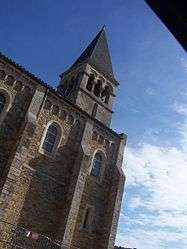
Plottes is a commune in the Saône-et-Loire department in the region of Bourgogne in eastern France.
Plottes was part of Tournus between January 1, 1973 and March 11, 2001.
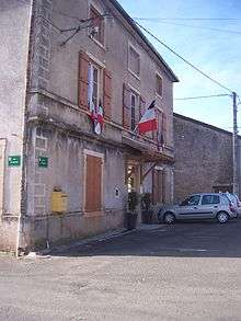
Town hall
See also
References
| Wikimedia Commons has media related to Plottes. |
This article is issued from Wikipedia - version of the 10/28/2016. The text is available under the Creative Commons Attribution/Share Alike but additional terms may apply for the media files.