Sainte-Colombe-de-la-Commanderie
| Sainte-Colombe-de-la-Commanderie | |
|---|---|
|
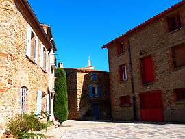
A square near the church in Sainte-Colombe-de-la-Commanderie | |
 Sainte-Colombe-de-la-Commanderie | |
|
Location within Occitanie region  Sainte-Colombe-de-la-Commanderie | |
| Coordinates: 42°36′56″N 2°44′55″E / 42.6156°N 2.7486°ECoordinates: 42°36′56″N 2°44′55″E / 42.6156°N 2.7486°E | |
| Country | France |
| Region | Occitanie |
| Department | Pyrénées-Orientales |
| Arrondissement | Perpignan |
| Canton | Thuir |
| Intercommunality | Aspres |
| Government | |
| • Mayor (2001–2008) | Alphonse Puig |
| Area1 | 4.74 km2 (1.83 sq mi) |
| Population (2006)2 | 115 |
| • Density | 24/km2 (63/sq mi) |
| Time zone | CET (UTC+1) |
| • Summer (DST) | CEST (UTC+2) |
| INSEE/Postal code | 66170 / 66300 |
| Elevation | 127–32 m (417–105 ft) |
|
1 French Land Register data, which excludes lakes, ponds, glaciers > 1 km² (0.386 sq mi or 247 acres) and river estuaries. 2 Population without double counting: residents of multiple communes (e.g., students and military personnel) only counted once. | |
Sainte-Colombe-de-la-Commanderie (Catalan: Santa Coloma de Tuïr) is a commune in the Pyrénées-Orientales department in southern France.
Geography
Sainte-Colombe-de-la-Commanderie is in the canton of Thuir and in the arrondissement of Perpignan.
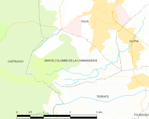
Map of Sainte-Colombe-de-la-Commanderie and its surrounding communes
Population
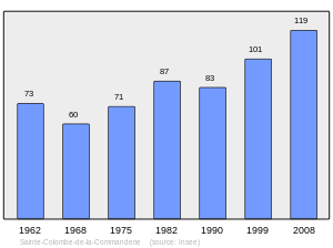
Population 1962-2008
See also
References
| Wikimedia Commons has media related to Sainte-Colombe-de-la-Commanderie. |
This article is issued from Wikipedia - version of the 2/3/2016. The text is available under the Creative Commons Attribution/Share Alike but additional terms may apply for the media files.