Canaveilles
| Canaveilles | |
|---|---|
|
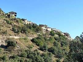
A general view of Canaveilles | |
 Canaveilles | |
|
Location within Occitanie region  Canaveilles | |
| Coordinates: 42°32′13″N 2°15′02″E / 42.5369°N 2.2506°ECoordinates: 42°32′13″N 2°15′02″E / 42.5369°N 2.2506°E | |
| Country | France |
| Region | Occitanie |
| Department | Pyrénées-Orientales |
| Arrondissement | Prades |
| Canton | Olette |
| Intercommunality | Conflent |
| Government | |
| • Mayor (2014–2020) | Bernard Malpas |
| Area1 | 10.95 km2 (4.23 sq mi) |
| Population (2013)2 | 46 |
| • Density | 4.2/km2 (11/sq mi) |
| Time zone | CET (UTC+1) |
| • Summer (DST) | CEST (UTC+2) |
| INSEE/Postal code | 66036 / 66360 |
| Elevation |
657–1,984 m (2,156–6,509 ft) (avg. 932 m or 3,058 ft) |
|
1 French Land Register data, which excludes lakes, ponds, glaciers > 1 km² (0.386 sq mi or 247 acres) and river estuaries. 2 Population without double counting: residents of multiple communes (e.g., students and military personnel) only counted once. | |
Canaveilles (Catalan: Canavelles) is a commune in the Pyrénées-Orientales department in southern France.
Geography
Localisation
Canaveilles is located in the canton of Olette and in the arrondissement of Prades.
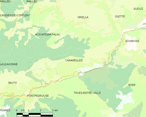
Map of Canaveilles and its surrounding communes
Neighbouring communes
| Ayguatébia-Talau | Oreilla (by a quadripoint) Olette Souanyas | ||
| Sauto | |
Nyer | |
| |||
| | |||
| Fontpédrouse | Thuès-Entre-Valls |

Population
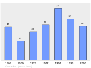
Population 1962-2008
See also
References
| Wikimedia Commons has media related to Canaveilles. |
This article is issued from Wikipedia - version of the 10/21/2016. The text is available under the Creative Commons Attribution/Share Alike but additional terms may apply for the media files.