La Cabanasse
| La Cabanasse La Cabanassa | ||
|---|---|---|
|
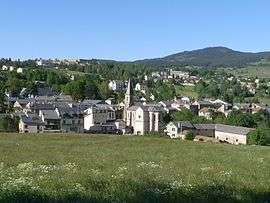
A general view of La Cabanasse | ||
| ||
 La Cabanasse | ||
|
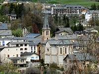
Location within Occitanie region  La Cabanasse | ||
| Coordinates: 42°30′08″N 2°06′56″E / 42.5022°N 2.1156°ECoordinates: 42°30′08″N 2°06′56″E / 42.5022°N 2.1156°E | ||
| Country | France | |
| Region | Occitanie | |
| Department | Pyrénées-Orientales | |
| Arrondissement | Prades | |
| Canton | Mont-Louis | |
| Intercommunality | Capcir Haut-Conflent | |
| Government | ||
| • Mayor (2014-2020) | François Delcasso | |
| Area1 | 3.26 km2 (1.26 sq mi) | |
| Population (2012)2 | 698 | |
| • Density | 210/km2 (550/sq mi) | |
| Time zone | CET (UTC+1) | |
| • Summer (DST) | CEST (UTC+2) | |
| INSEE/Postal code | 66027 / 66210 | |
| Elevation |
1,360–1,623 m (4,462–5,325 ft) (avg. 1,511 m or 4,957 ft) | |
|
1 French Land Register data, which excludes lakes, ponds, glaciers > 1 km² (0.386 sq mi or 247 acres) and river estuaries. 2 Population without double counting: residents of multiple communes (e.g., students and military personnel) only counted once. | ||

La Cabanasse (Catalan: La Cabanassa) is a commune in the Pyrénées-Orientales department in southern France.
Geography
Localisation
La Cabanasse is located in the canton of Mont-Louis and in the arrondissement of Prades.
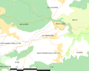
Map of La Cabanasse and its surrounding communes
Neighbouring communes
| La Llagonne | Mont-Louis | ||
| Bolquère | |
Sauto | |
| |||
| | |||
| Eyne | Saint-Pierre-dels-Forcats |

Population
La Cabanasse
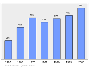
Population 1962-2008
See also
| Wikimedia Commons has media related to La Cabanasse. |
References
This article is issued from Wikipedia - version of the 9/28/2016. The text is available under the Creative Commons Attribution/Share Alike but additional terms may apply for the media files.