Corsavy
| Corsavy | |
|---|---|
|
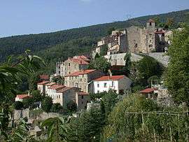
A general view of the village of Corsavy | |
 Corsavy | |
|
Location within Occitanie region  Corsavy | |
| Coordinates: 42°28′04″N 2°34′47″E / 42.4678°N 2.5797°ECoordinates: 42°28′04″N 2°34′47″E / 42.4678°N 2.5797°E | |
| Country | France |
| Region | Occitanie |
| Department | Pyrénées-Orientales |
| Arrondissement | Céret |
| Canton | Le Canigou |
| Intercommunality | Haut Vallespir |
| Government | |
| • Mayor (2014–2020) | Antoine Chrysostome |
| Area1 | 47.02 km2 (18.15 sq mi) |
| Population (2013)2 | 246 |
| • Density | 5.2/km2 (14/sq mi) |
| Time zone | CET (UTC+1) |
| • Summer (DST) | CEST (UTC+2) |
| INSEE/Postal code | 66060 / 66150 |
| Elevation |
345–2,721 m (1,132–8,927 ft) (avg. 800 m or 2,600 ft) |
|
1 French Land Register data, which excludes lakes, ponds, glaciers > 1 km² (0.386 sq mi or 247 acres) and river estuaries. 2 Population without double counting: residents of multiple communes (e.g., students and military personnel) only counted once. | |
Corsavy (Catalan: Cortsaví) is a commune in the Pyrénées-Orientales department in southern France. It is part of the historical Vallespir comarca.
Geography
Corsavy is located in the canton of Arles-sur-Tech and in the arrondissement of Céret.
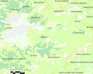
Map of Corsavy and its surrounding communes
Population
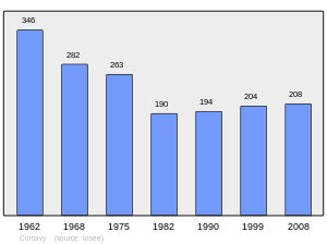
Population 1962-2008
See also
References
| Wikimedia Commons has media related to Corsavy. |
This article is issued from Wikipedia - version of the 9/28/2016. The text is available under the Creative Commons Attribution/Share Alike but additional terms may apply for the media files.