La Llagonne
| La Llagonne La Llaguna | ||
|---|---|---|
|
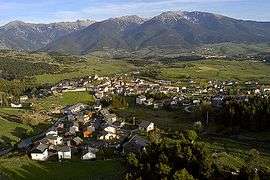
An aerial view of La Llagonne | ||
| ||
 La Llagonne | ||
|
Location within Occitanie region  La Llagonne | ||
| Coordinates: 42°31′38″N 2°07′18″E / 42.5272°N 2.1217°ECoordinates: 42°31′38″N 2°07′18″E / 42.5272°N 2.1217°E | ||
| Country | France | |
| Region | Occitanie | |
| Department | Pyrénées-Orientales | |
| Arrondissement | Prades | |
| Canton | Mont-Louis | |
| Intercommunality | Capcir Haut-Conflent | |
| Government | ||
| • Mayor (2014–2020) | Jean-Pierre Astruch | |
| Area1 | 23.09 km2 (8.92 sq mi) | |
| Population (1999)2 | 263 | |
| • Density | 11/km2 (30/sq mi) | |
| Time zone | CET (UTC+1) | |
| • Summer (DST) | CEST (UTC+2) | |
| INSEE/Postal code | 66098 / 66210 | |
| Elevation |
1,546–2,196 m (5,072–7,205 ft) (avg. 1,657 m or 5,436 ft) | |
|
1 French Land Register data, which excludes lakes, ponds, glaciers > 1 km² (0.386 sq mi or 247 acres) and river estuaries. 2 Population without double counting: residents of multiple communes (e.g., students and military personnel) only counted once. | ||

La Llagonne (Catalan: La Llaguna) is a commune in the Pyrénées-Orientales department in southern France.
Geography
La Llagonne is located in the canton of Mont-Louis and in the arrondissement of Prades.
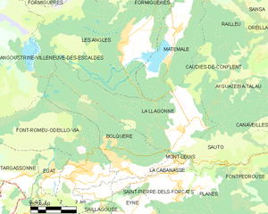
Map of La Llagonne and its surrounding communes
History
First time skiing in the Pyrénées happened on January 29, 1901 at La Llagonne.[1]
Population
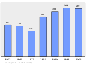
Population 1962-2008
See also
References
| Wikimedia Commons has media related to La Llagonne. |
This article is issued from Wikipedia - version of the 12/23/2015. The text is available under the Creative Commons Attribution/Share Alike but additional terms may apply for the media files.