Calmeilles
| Calmeilles | |
|---|---|
|
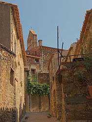
A street leading to the small square of Pedrissos, in Calmeilles | |
 Calmeilles | |
|
Location within Occitanie region  Calmeilles | |
| Coordinates: 42°33′11″N 2°40′30″E / 42.5531°N 2.675°ECoordinates: 42°33′11″N 2°40′30″E / 42.5531°N 2.675°E | |
| Country | France |
| Region | Occitanie |
| Department | Pyrénées-Orientales |
| Arrondissement | Céret |
| Canton | Céret |
| Intercommunality | Aspres |
| Government | |
| • Mayor (2014-2020) | Gérard Chinaud |
| Area1 | 13.22 km2 (5.10 sq mi) |
| Population (2012)2 | 65 |
| • Density | 4.9/km2 (13/sq mi) |
| Time zone | CET (UTC+1) |
| • Summer (DST) | CEST (UTC+2) |
| INSEE/Postal code | 66032 / 66400 |
| Elevation |
256–784 m (840–2,572 ft) (avg. 469 m or 1,539 ft) |
|
1 French Land Register data, which excludes lakes, ponds, glaciers > 1 km² (0.386 sq mi or 247 acres) and river estuaries. 2 Population without double counting: residents of multiple communes (e.g., students and military personnel) only counted once. | |
Calmeilles (Catalan: Calmella) is a commune in the Pyrénées-Orientales department in southern France.
Geography
Localisation
Calmeilles is located in the canton of Céret and in the arrondissement of Céret.
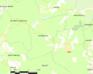
Map of Calmeilles and its surrounding communes
Neighbouring communes
| Caixas | Montauriol | ||
| Prunet-et-Belpuig | |
Oms | |
| |||
| | |||
| Saint-Marsal | Taillet |

Population
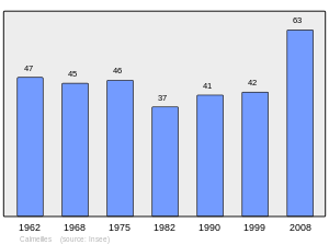
Population 1962-2008
See also
References
| Wikimedia Commons has media related to Calmeilles. |
This article is issued from Wikipedia - version of the 9/30/2016. The text is available under the Creative Commons Attribution/Share Alike but additional terms may apply for the media files.