Olette
- You may be looking for Olette (Kingdom Hearts)
| Olette | ||
|---|---|---|
|
A general view of Olette | ||
| ||
 Olette | ||
|
Location within Occitanie region  Olette | ||
| Coordinates: 42°33′22″N 2°16′14″E / 42.5561°N 2.2706°ECoordinates: 42°33′22″N 2°16′14″E / 42.5561°N 2.2706°E | ||
| Country | France | |
| Region | Occitanie | |
| Department | Pyrénées-Orientales | |
| Arrondissement | Prades | |
| Canton | Olette | |
| Government | ||
| • Mayor (2001–2008) | Jean-Louis Jallat | |
| Area1 | 28.95 km2 (11.18 sq mi) | |
| Population (2006)2 | 419 | |
| • Density | 14/km2 (37/sq mi) | |
| Time zone | CET (UTC+1) | |
| • Summer (DST) | CEST (UTC+2) | |
| INSEE/Postal code | 66125 / 66360 | |
| Elevation |
563–2,361 m (1,847–7,746 ft) (avg. 630 m or 2,070 ft) | |
|
1 French Land Register data, which excludes lakes, ponds, glaciers > 1 km² (0.386 sq mi or 247 acres) and river estuaries. 2 Population without double counting: residents of multiple communes (e.g., students and military personnel) only counted once. | ||
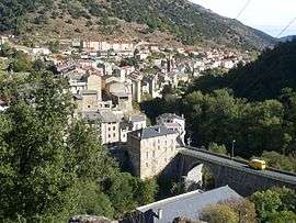

Olette (Catalan: Oleta i Èvol) is a commune in the Pyrénées-Orientales department in southern France.
Geography
Olette is located in the canton of Olette and in the arrondissement of Prades.
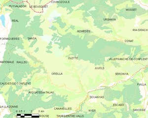
Map of Olette and its surrounding communes
Demography
| 1962 | 1968 | 1975 | 1982 | 1990 | 1999 | 2006 |
|---|---|---|---|---|---|---|
| 616 | 680 | 544 | 532 | 447 | 345 | 419 |
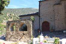
Ruined conjuratory in the Saint André church, Evol
See also
References
| Wikimedia Commons has media related to Olette. |
This article is issued from Wikipedia - version of the 4/18/2015. The text is available under the Creative Commons Attribution/Share Alike but additional terms may apply for the media files.